Vuyyūru geodata
Vuyyūru (Andhra Pradesh) is a populated place; located in India in Asia/Kolkata (GMT+5.5) time zone. With population of 36,755 people, there are 1193 cities with bigger population in this country. Compared to other cities in India, 77% of cities are located further ↑North; 72.4% of cities are located further ←West and 89.9% of cities have higher elevation than Vuyyūru. Note1


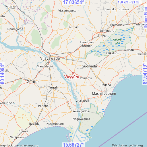
Vuyyūru GPS coordinates[2]
16° 21' 47.052" North, 80° 50' 38.616" East
| Map corner | latitude | longitude |
|---|---|---|
| Upper-left | 17.03654°, | 80.14094° |
| Center: | 16.36307°, | 80.84406° |
| Lower-right: | 15.68727°, | 81.54719° |
| Map W x H: | 150×150 km | = 93.2×93.2mi |
| max Lat: | 34.9274° ⇑77% North |
| Vuyyūru: | 16.36307° |
| min Lat: | ⇓23% South 8.09008° |
| min Long | Vuyyūru | max Long |
| 68.82655° | 80.84406° | 96.81° |
| W 72.4%⇐ | ⇒27.6% E |
Elevation
Elevation of Vuyyūru is 18 m = 59 ft, and this is 277.6 m = 911 ft below average elevation for this country.
| Max E: |
3681 m = 12077 ft | 89.9% |
| Avg. | 295.6 m = 970 ft | |
| Vuyyūru | 18 m = 59 ft | |
Min E: |
1 m = 3 ft | 10.1% |
See also: India elevation on elevation.city.
Geographical zone
Vuyyūru is located in North Torrid zone (between Equator and Tropic of Cancer). Distance of this Northern Tropic circle is 786.5 km =488.7 mi to North.| Distance of | km | miles | from Vuyyūru |
|---|---|---|---|
| North Pole | 8187.7 | 5087.6 | to North |
| Arctic Circle | 5581.8 | 3468.4 | to North |
| Tropic Cancer | 786.5 | 488.7 | to North |
| Equator | 1819.4 | 1130.5 | to South |


Nearby cities:
15 places around Vuyyūru: (largest is in red/bold)
• Avanigadda
38.8 km =24.1 mi,  168°
168°
• Bhattiprolu
29.7 km =18.5 mi,  193°
193°
• Challapalle
28.8 km =17.9 mi,  161°
161°
• Gannavaram
20.3 km =12.6 mi,  347°
347°
• Gudivāda
18.1 km =11.2 mi,  63°
63°
• Gudlavalleru
22 km =13.7 mi,  93°
93°
• Kankipādu
11.5 km =7.1 mi,  314°
314°
• Kolanukonda
26.9 km =16.7 mi,  292°
292°
• Machilīpatnam
37 km =23 mi,  121°
121°
• Mangalagiri
30.4 km =18.9 mi,  284°
284°
• Pedana
34.1 km =21.2 mi,  110°
110°
• Repalle
38.4 km =23.9 mi,  182°
182°
• Tādepalle
29.3 km =18.2 mi,  297°
297°
• Vijayawada
26.5 km =16.5 mi, 307°
• Yanamalakuduru
23.2 km =14.4 mi, 305°
Sources, notices
• [Note1] Compared only with cities in India existing in our database
• [Src1] Map data: © OpenStreetMap contributors (CC-BY-SA)
• [Src2] Other city data from geonames.org with taken over terms of usage.
• [Src3] Geographical zone / Annual Mean Temperature by Robert A. Rohde @ Wikipedia
