Nūzvīd geodata
Nūzvīd (Andhra Pradesh) is a populated place; located in India in Asia/Kolkata (GMT+5.5) time zone. With population of 53,391 people, there are 831 cities with bigger population in this country. Compared to other cities in India, 75.4% of cities are located further ↑North; 72.5% of cities are located further ←West and 66.2% of cities have higher elevation than Nūzvīd. Note1


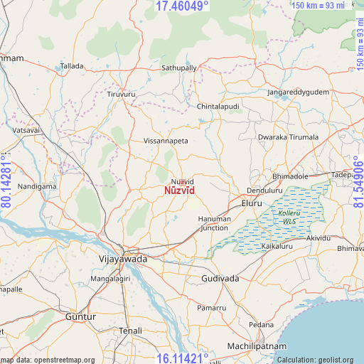
Nūzvīd GPS coordinates[2]
16° 47' 18.744" North, 80° 50' 45.348" East
| Map corner | latitude | longitude |
|---|---|---|
| Upper-left | 17.46049°, | 80.14281° |
| Center: | 16.78854°, | 80.84593° |
| Lower-right: | 16.11421°, | 81.54906° |
| Map W x H: | 149.7×149.7 km | = 93×93mi |
| max Lat: | 34.9274° ⇑75.4% North |
| Nūzvīd: | 16.78854° |
| min Lat: | ⇓24.6% South 8.09008° |
| min Long | Nūzvīd | max Long |
| 68.82655° | 80.84593° | 96.81° |
| W 72.5%⇐ | ⇒27.5% E |
Elevation
Elevation of Nūzvīd is 112 m = 367 ft, and this is 183.6 m = 602 ft below average elevation for this country.
| Max E: |
3681 m = 12077 ft | 66.2% |
| Avg. | 295.6 m = 970 ft | |
| Nūzvīd | 112 m = 367 ft | |
Min E: |
1 m = 3 ft | 33.8% |
See also: Nūzvīd elevation on elevation.city.
Geographical zone
Nūzvīd is located in North Torrid zone (between Equator and Tropic of Cancer). Distance of this Northern Tropic circle is 739.2 km =459.3 mi to North.| Distance of | km | miles | from Nūzvīd |
|---|---|---|---|
| North Pole | 8140.4 | 5058.2 | to North |
| Arctic Circle | 5534.5 | 3439 | to North |
| Tropic Cancer | 739.2 | 459.3 | to North |
| Equator | 1866.7 | 1159.9 | to South |


Nearby cities:
15 places around Nūzvīd: (largest is in red/bold)
• Ellore
28.8 km =17.9 mi,  106°
106°
• Gannavaram
27.9 km =17.3 mi,  189°
189°
• Gudivāda
42.4 km =26.3 mi,  157°
157°
• Gudlavalleru
53.4 km =33.2 mi, 155°
• Kaikalūr
47.2 km =29.3 mi,  123°
123°
• Kankipādu
40.2 km =25 mi, 192°
• Kolanukonda
44.9 km =27.9 mi,  213°
213°
• Kondapalle
37.4 km =23.2 mi,  239°
239°
• Mangalagiri
49.6 km =30.8 mi,  216°
216°
• Pallevāda
53.2 km =33.1 mi, 116°
• Sathupalli
51.3 km =31.9 mi,  2°
2°
• Tādepalle
42.9 km =26.7 mi, 217°
• Vijayawada
37.8 km =23.5 mi, 214°
• Vuyyūru
47.3 km =29.4 mi,  180°
180°
• Yanamalakuduru
38.7 km =24 mi, 209°
Sources, notices
• [Note1] Compared only with cities in India existing in our database
• [Src1] Map data: © OpenStreetMap contributors (CC-BY-SA)
• [Src2] Other city data from geonames.org with taken over terms of usage.
• [Src3] Geographical zone / Annual Mean Temperature by Robert A. Rohde @ Wikipedia
