Tādepalle geodata
Tādepalle (Andhra Pradesh) is a populated place; located in India in Asia/Kolkata (GMT+5.5) time zone. With population of 34,357 people, there are 1267 cities with bigger population in this country. Compared to other cities in India, 76.5% of cities are located further ↑North; 71.4% of cities are located further ←West and 78.3% of cities have higher elevation than Tādepalle. Note1


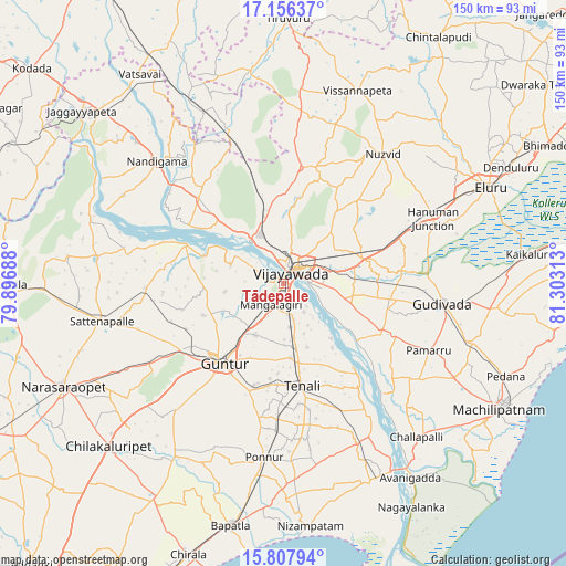
Tādepalle GPS coordinates[2]
16° 28' 59.988" North, 80° 36' 0" East
| Map corner | latitude | longitude |
|---|---|---|
| Upper-left | 17.15637°, | 79.89688° |
| Center: | 16.48333°, | 80.6° |
| Lower-right: | 15.80794°, | 81.30313° |
| Map W x H: | 149.9×149.9 km | = 93.1×93.1mi |
| max Lat: | 34.9274° ⇑76.5% North |
| Tādepalle: | 16.48333° |
| min Lat: | ⇓23.5% South 8.09008° |
| min Long | Tādepalle | max Long |
| 68.82655° | 80.6° | 96.81° |
| W 71.4%⇐ | ⇒28.6% E |
Elevation
Elevation of Tādepalle is 54 m = 177 ft, and this is 241.6 m = 793 ft below average elevation for this country.
| Max E: |
3681 m = 12077 ft | 78.3% |
| Avg. | 295.6 m = 970 ft | |
| Tādepalle | 54 m = 177 ft | |
Min E: |
1 m = 3 ft | 21.7% |
See also: India elevation on elevation.city.
Geographical zone
Tādepalle is located in North Torrid zone (between Equator and Tropic of Cancer). Distance of this Northern Tropic circle is 773.1 km =480.4 mi to North.| Distance of | km | miles | from Tādepalle |
|---|---|---|---|
| North Pole | 8174.3 | 5079.3 | to North |
| Arctic Circle | 5568.4 | 3460 | to North |
| Tropic Cancer | 773.1 | 480.4 | to North |
| Equator | 1832.8 | 1138.8 | to South |


Nearby cities:
15 places around Tādepalle: (largest is in red/bold)
• Bhattiprolu
46.5 km =28.9 mi,  155°
155°
• Gannavaram
22.5 km =14 mi,  73°
73°
• Gudivāda
42.5 km =26.4 mi,  97°
97°
• Guntur
25.5 km =15.8 mi,  216°
216°
• Kankipādu
18.6 km =11.6 mi,  106°
106°
• Kolanukonda
3.5 km =2.2 mi, 161°
• Kondapalle
16.4 km =10.2 mi,  337°
337°
• Mangalagiri
6.8 km =4.2 mi,  210°
210°
• Nandigāma
46.3 km =28.8 mi,  313°
313°
• Nūzvīd
42.9 km =26.7 mi,  37°
37°
• Phirangipuram
41.9 km =26 mi,  239°
239°
• Ponnur
46.1 km =28.6 mi,  186°
186°
• Vijayawada
5.6 km =3.5 mi,  61°
61°
• Vuyyūru
29.3 km =18.2 mi,  117°
117°
• Yanamalakuduru
7.2 km =4.5 mi,  88°
88°
Sources, notices
• [Note1] Compared only with cities in India existing in our database
• [Src1] Map data: © OpenStreetMap contributors (CC-BY-SA)
• [Src2] Other city data from geonames.org with taken over terms of usage.
• [Src3] Geographical zone / Annual Mean Temperature by Robert A. Rohde @ Wikipedia
