Gudivāda geodata
Gudivāda (Andhra Pradesh) is a populated place; located in India in Asia/Kolkata (GMT+5.5) time zone. With population of 116,161 people, there are 382 cities with bigger population in this country. Compared to other cities in India, 76.7% of cities are located further ↑North; 72.9% of cities are located further ←West and 93.5% of cities have higher elevation than Gudivāda. Note1


Gudivāda GPS coordinates[2]
16° 26' 7.692" North, 80° 59' 43.98" East
| Map corner | latitude | longitude |
|---|---|---|
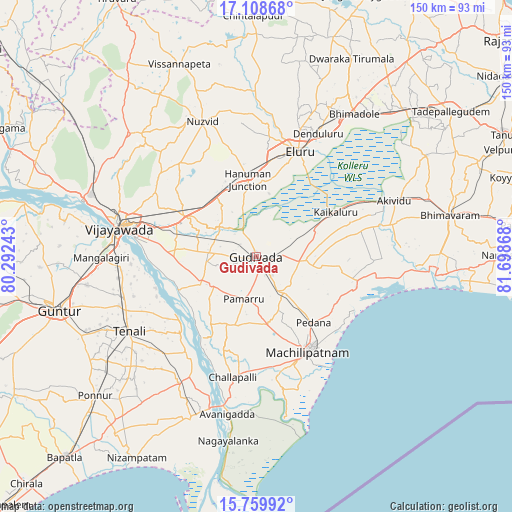
| Upper-left | 17.10868°, | 80.29243° |
| Center: | 16.43547°, | 80.99555° |
| Lower-right: | 15.75992°, | 81.69868° |
| Map W x H: | 150×150 km | = 93.2×93.2mi |
| max Lat: | 34.9274° ⇑76.7% North |
| Gudivāda: | 16.43547° |
| min Lat: | ⇓23.3% South 8.09008° |
| min Long | Gudivāda | max Long |
| 68.82655° | 80.99555° | 96.81° |
| W 72.9%⇐ | ⇒27.1% E |
Elevation
Elevation of Gudivāda is 13 m = 43 ft, and this is 282.6 m = 927 ft below average elevation for this country.
| Max E: |
3681 m = 12077 ft | 93.5% |
| Avg. | 295.6 m = 970 ft | |
| Gudivāda | 13 m = 43 ft | |
Min E: |
1 m = 3 ft | 6.5% |
See also: Gudivāda elevation on elevation.city.
Geographical zone
Gudivāda is located in North Torrid zone (between Equator and Tropic of Cancer). Distance of this Northern Tropic circle is 778.5 km =483.7 mi to North.| Distance of | km | miles | from Gudivāda |
|---|---|---|---|
| North Pole | 8179.6 | 5082.6 | to North |
| Arctic Circle | 5573.7 | 3463.3 | to North |
| Tropic Cancer | 778.5 | 483.7 | to North |
| Equator | 1827.5 | 1135.6 | to South |


Nearby cities:
15 places around Gudivāda: (largest is in red/bold)
• Challapalle
36 km =22.4 mi,  190°
190°
• Ellore
33 km =20.5 mi,  20°
20°
• Gannavaram
23.7 km =14.7 mi,  299°
299°
• Gudlavalleru
11.1 km =6.9 mi,  148°
148°
• Kaikalūr
26.6 km =16.5 mi,  61°
61°
• Kankipādu
24.4 km =15.2 mi,  269°
269°
• Kanuru
32.3 km =20.1 mi,  121°
121°
• Kolanukonda
41.1 km =25.5 mi, 272°
• Korukollu
28.1 km =17.5 mi,  75°
75°
• Machilīpatnam
31.5 km =19.6 mi, 150°
• Pallevāda
35.6 km =22.1 mi, 63°
• Pedana
25.5 km =15.8 mi,  141°
141°
• Vijayawada
38.1 km =23.7 mi,  282°
282°
• Vuyyūru
18.1 km =11.2 mi,  243°
243°
• Yanamalakuduru
35.4 km =22 mi, 279°
Sources, notices
• [Note1] Compared only with cities in India existing in our database
• [Src1] Map data: © OpenStreetMap contributors (CC-BY-SA)
• [Src2] Other city data from geonames.org with taken over terms of usage.
• [Src3] Geographical zone / Annual Mean Temperature by Robert A. Rohde @ Wikipedia
