Vijayapuri geodata
Vijayapuri (Tamil Nadu) is a populated place; located in India in Asia/Kolkata (GMT+5.5) time zone. With population of 6,651 people, there are 3237 cities with bigger population in this country. Compared to other cities in India, 92.2% of cities are located further ↑North; 57.2% of cities are located further →East and 67.2% of cities have lower elevation than Vijayapuri. Note1


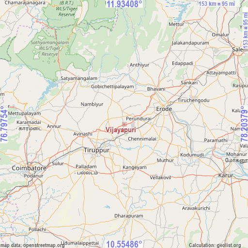
Vijayapuri GPS coordinates[2]
11° 14' 43.08" North, 77° 30' 2.376" East
| Map corner | latitude | longitude |
|---|---|---|
| Upper-left | 11.93408°, | 76.79754° |
| Center: | 11.2453°, | 77.50066° |
| Lower-right: | 10.55486°, | 78.20379° |
| Map W x H: | 153.4×153.4 km | = 95.3×95.3mi |
| max Lat: | 34.9274° ⇑92.2% North |
| Vijayapuri: | 11.2453° |
| min Lat: | ⇓7.8% South 8.09008° |
| min Long | Vijayapuri | max Long |
| 68.82655° | 77.50066° | 96.81° |
| W 42.8%⇐ | ⇒57.2% E |
Elevation
Elevation of Vijayapuri is 303 m = 994 ft, and this is 7.4 m = 24 ft above average elevation for this country.
| Max E: |
3681 m = 12077 ft | 32.8% |
| Vijayapuri | 303 m 994 ft | |
| Avg. | 295.6 m = 970 ft | |
Min E: |
1 m = 3 ft | 67.2% |
See also: India elevation on elevation.city.
Geographical zone
Vijayapuri is located in North Torrid zone (between Equator and Tropic of Cancer). Distance of Equator is 1250.4 km =777 mi to South.| Distance of | km | miles | from Vijayapuri |
|---|---|---|---|
| North Pole | 8756.7 | 5441.2 | to North |
| Arctic Circle | 6150.8 | 3821.9 | to North |
| Tropic Cancer | 1355.6 | 842.3 | to North |
| Equator | 1250.4 | 777 | to South |


Nearby cities:
15 places around Vijayapuri: (largest is in red/bold)
• Anthiyur
37.9 km =23.5 mi,  14°
14°
• Avinashi
26 km =16.2 mi,  257°
257°
• Bhavāni
29.8 km =18.5 mi,  41°
41°
• Chennimalai
14.5 km =9 mi,  128°
128°
• Erode
27 km =16.8 mi,  66°
66°
• Gobichettipalayam
24.2 km =15 mi,  344°
344°
• Kangayam
27.4 km =17 mi,  166°
166°
• Nambiyūr
23.2 km =14.4 mi,  302°
302°
• Palladam
36.6 km =22.7 mi,  219°
219°
• Perundurai
10.1 km =6.3 mi, 70°
• Punjai Puliyampatti
38.3 km =23.8 mi,  287°
287°
• Sathyamangalam
40.7 km =25.3 mi,  315°
315°
• Sivagiri
34.3 km =21.3 mi,  113°
113°
• Tiruppur
21.5 km =13.4 mi,  227°
227°
• Ūttukkuli
9.9 km =6.2 mi,  210°
210°
Sources, notices
• [Note1] Compared only with cities in India existing in our database
• [Src1] Map data: © OpenStreetMap contributors (CC-BY-SA)
• [Src2] Other city data from geonames.org with taken over terms of usage.
• [Src3] Geographical zone / Annual Mean Temperature by Robert A. Rohde @ Wikipedia
