Sathyamangalam geodata
Sathyamangalam (Tamil Nadu) is a populated place; located in India in Asia/Kolkata (GMT+5.5) time zone. With population of 34,011 people, there are 1280 cities with bigger population in this country. Compared to other cities in India, 91.3% of cities are located further ↑North; 60.7% of cities are located further →East and 58% of cities have lower elevation than Sathyamangalam. Note1


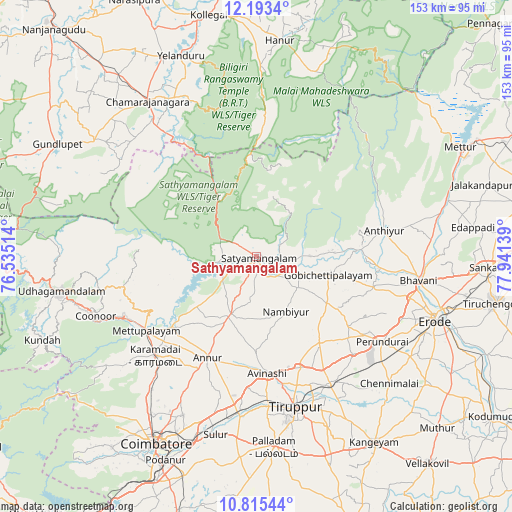
Sathyamangalam GPS coordinates[2]
11° 30' 18.936" North, 77° 14' 17.736" East
| Map corner | latitude | longitude |
|---|---|---|
| Upper-left | 12.1934°, | 76.53514° |
| Center: | 11.50526°, | 77.23826° |
| Lower-right: | 10.81544°, | 77.94139° |
| Map W x H: | 153.2×153.2 km | = 95.2×95.2mi |
| max Lat: | 34.9274° ⇑91.3% North |
| Sathyamangalam: | 11.50526° |
| min Lat: | ⇓8.7% South 8.09008° |
| min Long | Sathyamangalam | max Long |
| 68.82655° | 77.23826° | 96.81° |
| W 39.3%⇐ | ⇒60.7% E |
Elevation
Elevation of Sathyamangalam is 239 m = 784 ft, and this is 56.6 m = 186 ft below average elevation for this country.
| Max E: |
3681 m = 12077 ft | 42% |
| Avg. | 295.6 m = 970 ft | |
| Sathyamangalam | 239 m = 784 ft | |
Min E: |
1 m = 3 ft | 58% |
See also: India elevation on elevation.city.
Geographical zone
Sathyamangalam is located in North Torrid zone (between Equator and Tropic of Cancer). Distance of Equator is 1279.3 km =794.9 mi to South.| Distance of | km | miles | from Sathyamangalam |
|---|---|---|---|
| North Pole | 8727.8 | 5423.2 | to North |
| Arctic Circle | 6121.9 | 3804 | to North |
| Tropic Cancer | 1326.7 | 824.4 | to North |
| Equator | 1279.3 | 794.9 | to South |


Nearby cities:
15 places around Sathyamangalam: (largest is in red/bold)
• Annur
33.3 km =20.7 mi,  205°
205°
• Anthiyur
39.1 km =24.3 mi,  78°
78°
• Avinashi
34.9 km =21.7 mi,  174°
174°
• Bhavāni
48.8 km =30.3 mi,  97°
97°
• Gobichettipalayam
22.9 km =14.2 mi, 104°
• Kotagiri
42.2 km =26.2 mi,  257°
257°
• Kāramadai
42.3 km =26.3 mi,  225°
225°
• Mettupalayam
40.2 km =25 mi,  235°
235°
• Nambiyūr
18.7 km =11.6 mi,  151°
151°
• Perundurai
45.9 km =28.5 mi,  123°
123°
• Punjai Puliyampatti
18.8 km =11.7 mi,  204°
204°
• Sirumugai
32.6 km =20.3 mi, 231°
• Tiruppur
45.2 km =28.1 mi,  163°
163°
• Vijayapuri
40.7 km =25.3 mi,  135°
135°
• Ūttukkuli
44.2 km =27.5 mi, 147°
Sources, notices
• [Note1] Compared only with cities in India existing in our database
• [Src1] Map data: © OpenStreetMap contributors (CC-BY-SA)
• [Src2] Other city data from geonames.org with taken over terms of usage.
• [Src3] Geographical zone / Annual Mean Temperature by Robert A. Rohde @ Wikipedia
