Palladam geodata
Palladam (Tamil Nadu) is a populated place; located in India in Asia/Kolkata (GMT+5.5) time zone. With population of 31,935 people, there are 1361 cities with bigger population in this country. Compared to other cities in India, 93.3% of cities are located further ↑North; 60.1% of cities are located further →East and 73.8% of cities have lower elevation than Palladam. Note1


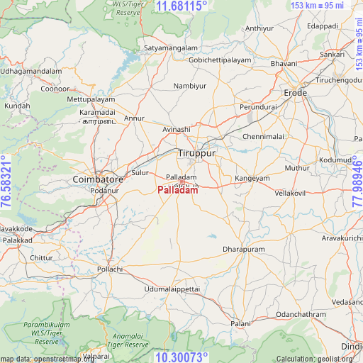
Palladam GPS coordinates[2]
10° 59' 30.3" North, 77° 17' 10.788" East
| Map corner | latitude | longitude |
|---|---|---|
| Upper-left | 11.68115°, | 76.58321° |
| Center: | 10.99175°, | 77.28633° |
| Lower-right: | 10.30073°, | 77.98946° |
| Map W x H: | 153.5×153.5 km | = 95.4×95.4mi |
| max Lat: | 34.9274° ⇑93.3% North |
| Palladam: | 10.99175° |
| min Lat: | ⇓6.7% South 8.09008° |
| min Long | Palladam | max Long |
| 68.82655° | 77.28633° | 96.81° |
| W 39.9%⇐ | ⇒60.1% E |
Elevation
Elevation of Palladam is 371 m = 1217 ft, and this is 75.4 m = 247 ft above average elevation for this country.
| Max E: |
3681 m = 12077 ft | 26.2% |
| Palladam | 371 m 1217 ft | |
| Avg. | 295.6 m = 970 ft | |
Min E: |
1 m = 3 ft | 73.8% |
See also: India elevation on elevation.city.
Geographical zone
Palladam is located in North Torrid zone (between Equator and Tropic of Cancer). Distance of Equator is 1222.2 km =759.4 mi to South.| Distance of | km | miles | from Palladam |
|---|---|---|---|
| North Pole | 8784.9 | 5458.7 | to North |
| Arctic Circle | 6179 | 3839.5 | to North |
| Tropic Cancer | 1383.8 | 859.9 | to North |
| Equator | 1222.2 | 759.4 | to South |


Nearby cities:
15 places around Palladam: (largest is in red/bold)
• Annur
33.6 km =20.9 mi,  323°
323°
• Avinashi
22.5 km =14 mi,  355°
355°
• Chettipālaiyam
28.6 km =17.8 mi,  252°
252°
• Coimbatore
35 km =21.7 mi,  272°
272°
• Dharapuram
38.9 km =24.2 mi,  136°
136°
• Irugūr
24.6 km =15.3 mi,  276°
276°
• Kangayam
30 km =18.6 mi,  86°
86°
• Madukkarai
36.5 km =22.7 mi, 254°
• Periyanegamam
34.1 km =21.2 mi,  215°
215°
• Periyapatti
26 km =16.2 mi,  183°
183°
• Singānallūr
27.7 km =17.2 mi, 271°
• Sulur
17.9 km =11.1 mi, 281°
• Tiruppur
15.6 km =9.7 mi,  28°
28°
• Vijayapuri
36.6 km =22.7 mi,  39°
39°
• Ūttukkuli
26.9 km =16.7 mi, 42°
Sources, notices
• [Note1] Compared only with cities in India existing in our database
• [Src1] Map data: © OpenStreetMap contributors (CC-BY-SA)
• [Src2] Other city data from geonames.org with taken over terms of usage.
• [Src3] Geographical zone / Annual Mean Temperature by Robert A. Rohde @ Wikipedia
