Erode geodata
Erode (Tamil Nadu) is a populated place; located in India in Asia/Kolkata (GMT+5.5) time zone. With population of 147,270 people, there are 298 cities with bigger population in this country. Compared to other cities in India, 91.9% of cities are located further ↑North; 54.6% of cities are located further →East and 56% of cities have higher elevation than Erode. Note1


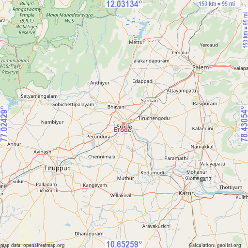
Erode GPS coordinates[2]
11° 20' 34.08" North, 77° 43' 38.676" East
| Map corner | latitude | longitude |
|---|---|---|
| Upper-left | 12.03134°, | 77.02429° |
| Center: | 11.3428°, | 77.72741° |
| Lower-right: | 10.65259°, | 78.43054° |
| Map W x H: | 153.3×153.3 km | = 95.3×95.3mi |
| max Lat: | 34.9274° ⇑91.9% North |
| Erode: | 11.3428° |
| min Lat: | ⇓8.1% South 8.09008° |
| min Long | Erode | max Long |
| 68.82655° | 77.72741° | 96.81° |
| W 45.4%⇐ | ⇒54.6% E |
Elevation
Elevation of Erode is 170 m = 558 ft, and this is 125.6 m = 412 ft below average elevation for this country.
| Max E: |
3681 m = 12077 ft | 56% |
| Avg. | 295.6 m = 970 ft | |
| Erode | 170 m = 558 ft | |
Min E: |
1 m = 3 ft | 44% |
See also: Erode elevation on elevation.city.
Geographical zone
Erode is located in North Torrid zone (between Equator and Tropic of Cancer). Distance of Equator is 1261.2 km =783.7 mi to South.| Distance of | km | miles | from Erode |
|---|---|---|---|
| North Pole | 8745.9 | 5434.4 | to North |
| Arctic Circle | 6140 | 3815.2 | to North |
| Tropic Cancer | 1344.7 | 835.6 | to North |
| Equator | 1261.2 | 783.7 | to South |


Nearby cities:
15 places around Erode: (largest is in red/bold)
• Ammāpettai
30.8 km =19.1 mi,  3°
3°
• Anthiyur
29.8 km =18.5 mi,  329°
329°
• Bhavāni
12.4 km =7.7 mi,  336°
336°
• Chennimalai
24 km =14.9 mi,  214°
214°
• Gobichettipalayam
33.5 km =20.8 mi,  291°
291°
• Idappadi
29.7 km =18.5 mi,  24°
24°
• Kodumudi
34.1 km =21.2 mi,  149°
149°
• Konganāpuram
31.6 km =19.6 mi,  36°
36°
• Mallasamudram
37.1 km =23.1 mi,  63°
63°
• Perundurai
16.9 km =10.5 mi,  243°
243°
• Sivagiri
25.6 km =15.9 mi,  165°
165°
• Tiruchengode
18.7 km =11.6 mi,  77°
77°
• Velur
39.6 km =24.6 mi,  131°
131°
• Vijayapuri
27 km =16.8 mi,  246°
246°
• Ūttukkuli
35.5 km =22.1 mi, 237°
Sources, notices
• [Note1] Compared only with cities in India existing in our database
• [Src1] Map data: © OpenStreetMap contributors (CC-BY-SA)
• [Src2] Other city data from geonames.org with taken over terms of usage.
• [Src3] Geographical zone / Annual Mean Temperature by Robert A. Rohde @ Wikipedia
