Avinashi geodata
Avinashi (Tamil Nadu) is a populated place; located in India in Asia/Kolkata (GMT+5.5) time zone. With population of 24,327 people, there are 1745 cities with bigger population in this country. Compared to other cities in India, 92.4% of cities are located further ↑North; 60.4% of cities are located further →East and 70.3% of cities have lower elevation than Avinashi. Note1


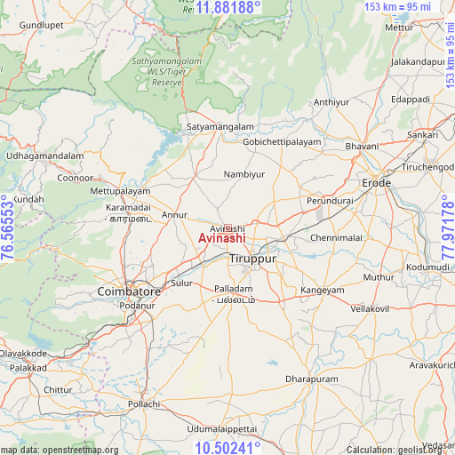
Avinashi GPS coordinates[2]
11° 11' 34.692" North, 77° 16' 7.14" East
| Map corner | latitude | longitude |
|---|---|---|
| Upper-left | 11.88188°, | 76.56553° |
| Center: | 11.19297°, | 77.26865° |
| Lower-right: | 10.50241°, | 77.97178° |
| Map W x H: | 153.4×153.4 km | = 95.3×95.3mi |
| max Lat: | 34.9274° ⇑92.4% North |
| Avinashi: | 11.19297° |
| min Lat: | ⇓7.6% South 8.09008° |
| min Long | Avinashi | max Long |
| 68.82655° | 77.26865° | 96.81° |
| W 39.6%⇐ | ⇒60.4% E |
Elevation
Elevation of Avinashi is 330 m = 1083 ft, and this is 34.4 m = 113 ft above average elevation for this country.
| Max E: |
3681 m = 12077 ft | 29.7% |
| Avinashi | 330 m 1083 ft | |
| Avg. | 295.6 m = 970 ft | |
Min E: |
1 m = 3 ft | 70.3% |
See also: India elevation on elevation.city.
Geographical zone
Avinashi is located in North Torrid zone (between Equator and Tropic of Cancer). Distance of Equator is 1244.5 km =773.3 mi to South.| Distance of | km | miles | from Avinashi |
|---|---|---|---|
| North Pole | 8762.5 | 5444.8 | to North |
| Arctic Circle | 6156.6 | 3825.5 | to North |
| Tropic Cancer | 1361.4 | 845.9 | to North |
| Equator | 1244.5 | 773.3 | to South |


Nearby cities:
15 places around Avinashi: (largest is in red/bold)
• Annur
18.5 km =11.5 mi,  285°
285°
• Gobichettipalayam
34.7 km =21.6 mi,  33°
33°
• Irugūr
29.7 km =18.5 mi,  229°
229°
• Kāramadai
34.1 km =21.2 mi,  278°
278°
• Nambiyūr
19.2 km =11.9 mi,  17°
17°
• Palladam
22.5 km =14 mi,  175°
175°
• Periyanayakkanpalaiyam
34.9 km =21.7 mi,  262°
262°
• Punjai Puliyampatti
20.9 km =13 mi,  327°
327°
• Sathyamangalam
34.9 km =21.7 mi,  354°
354°
• Singānallūr
33.6 km =20.9 mi, 230°
• Sirumugai
32.1 km =19.9 mi,  296°
296°
• Sulur
24.4 km =15.2 mi,  219°
219°
• Tiruppur
12.7 km =7.9 mi,  132°
132°
• Vijayapuri
26 km =16.2 mi,  77°
77°
• Ūttukkuli
20.4 km =12.7 mi,  97°
97°
Sources, notices
• [Note1] Compared only with cities in India existing in our database
• [Src1] Map data: © OpenStreetMap contributors (CC-BY-SA)
• [Src2] Other city data from geonames.org with taken over terms of usage.
• [Src3] Geographical zone / Annual Mean Temperature by Robert A. Rohde @ Wikipedia
