Kangayam geodata
Kangayam (Tamil Nadu) is a populated place; located in India in Asia/Kolkata (GMT+5.5) time zone. With population of 31,364 people, there are 1384 cities with bigger population in this country. Compared to other cities in India, 93.1% of cities are located further ↑North; 56.5% of cities are located further →East and 68.3% of cities have lower elevation than Kangayam. Note1


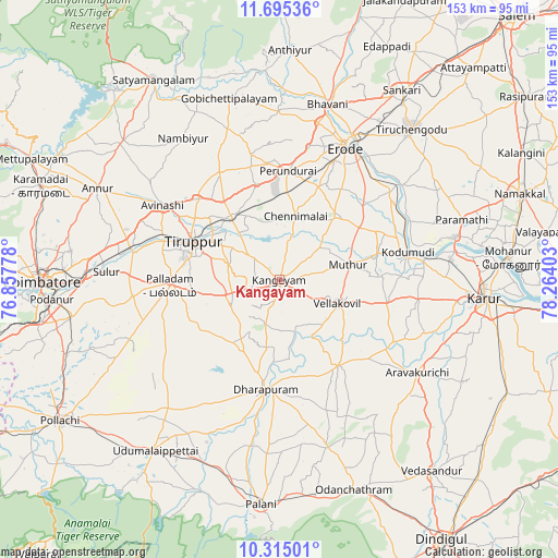
Kangayam GPS coordinates[2]
11° 0' 21.564" North, 77° 33' 39.24" East
| Map corner | latitude | longitude |
|---|---|---|
| Upper-left | 11.69536°, | 76.85778° |
| Center: | 11.00599°, | 77.5609° |
| Lower-right: | 10.31501°, | 78.26403° |
| Map W x H: | 153.5×153.5 km | = 95.4×95.4mi |
| max Lat: | 34.9274° ⇑93.1% North |
| Kangayam: | 11.00599° |
| min Lat: | ⇓6.9% South 8.09008° |
| min Long | Kangayam | max Long |
| 68.82655° | 77.5609° | 96.81° |
| W 43.5%⇐ | ⇒56.5% E |
Elevation
Elevation of Kangayam is 310 m = 1017 ft, and this is 14.4 m = 47 ft above average elevation for this country.
| Max E: |
3681 m = 12077 ft | 31.7% |
| Kangayam | 310 m 1017 ft | |
| Avg. | 295.6 m = 970 ft | |
Min E: |
1 m = 3 ft | 68.3% |
See also: India elevation on elevation.city.
Geographical zone
Kangayam is located in North Torrid zone (between Equator and Tropic of Cancer). Distance of Equator is 1223.8 km =760.4 mi to South.| Distance of | km | miles | from Kangayam |
|---|---|---|---|
| North Pole | 8783.3 | 5457.7 | to North |
| Arctic Circle | 6177.4 | 3838.5 | to North |
| Tropic Cancer | 1382.2 | 858.9 | to North |
| Equator | 1223.8 | 760.4 | to South |


Nearby cities:
15 places around Kangayam: (largest is in red/bold)
• Avinashi
38.1 km =23.7 mi,  303°
303°
• Chennimalai
18.2 km =11.3 mi,  14°
14°
• Dharapuram
29.9 km =18.6 mi,  186°
186°
• Erode
41.6 km =25.8 mi,  25°
25°
• Kodumudi
36.1 km =22.4 mi,  77°
77°
• Kīranūr
46.2 km =28.7 mi, 187°
• Mūlanūr
28.7 km =17.8 mi,  145°
145°
• Palladam
30 km =18.6 mi,  266°
266°
• Pallappatti
47.1 km =29.3 mi,  132°
132°
• Periyapatti
42 km =26.1 mi,  228°
228°
• Perundurai
30.1 km =18.7 mi, 5°
• Sivagiri
27.9 km =17.3 mi,  62°
62°
• Tiruppur
25.6 km =15.9 mi, 298°
• Vijayapuri
27.4 km =17 mi,  346°
346°
• Ūttukkuli
21.5 km =13.4 mi,  327°
327°
Sources, notices
• [Note1] Compared only with cities in India existing in our database
• [Src1] Map data: © OpenStreetMap contributors (CC-BY-SA)
• [Src2] Other city data from geonames.org with taken over terms of usage.
• [Src3] Geographical zone / Annual Mean Temperature by Robert A. Rohde @ Wikipedia
