Perundurai geodata
Perundurai (Tamil Nadu) is a populated place; located in India in Asia/Kolkata (GMT+5.5) time zone. With population of 17,488 people, there are 2241 cities with bigger population in this country. Compared to other cities in India, 92.1% of cities are located further ↑North; 56.3% of cities are located further →East and 64.5% of cities have lower elevation than Perundurai. Note1


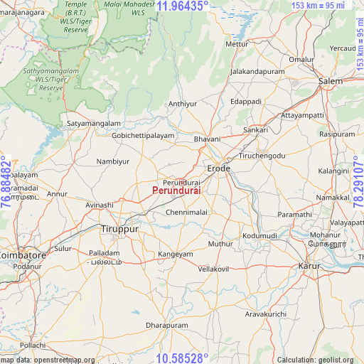
Perundurai GPS coordinates[2]
11° 16' 32.304" North, 77° 35' 16.584" East
| Map corner | latitude | longitude |
|---|---|---|
| Upper-left | 11.96435°, | 76.88482° |
| Center: | 11.27564°, | 77.58794° |
| Lower-right: | 10.58528°, | 78.29107° |
| Map W x H: | 153.3×153.3 km | = 95.3×95.3mi |
| max Lat: | 34.9274° ⇑92.1% North |
| Perundurai: | 11.27564° |
| min Lat: | ⇓7.9% South 8.09008° |
| min Long | Perundurai | max Long |
| 68.82655° | 77.58794° | 96.81° |
| W 43.7%⇐ | ⇒56.3% E |
Elevation
Elevation of Perundurai is 282 m = 925 ft, and this is 13.6 m = 45 ft below average elevation for this country.
| Max E: |
3681 m = 12077 ft | 35.5% |
| Avg. | 295.6 m = 970 ft | |
| Perundurai | 282 m = 925 ft | |
Min E: |
1 m = 3 ft | 64.5% |
See also: India elevation on elevation.city.
Geographical zone
Perundurai is located in North Torrid zone (between Equator and Tropic of Cancer). Distance of Equator is 1253.7 km =779 mi to South.| Distance of | km | miles | from Perundurai |
|---|---|---|---|
| North Pole | 8753.3 | 5439 | to North |
| Arctic Circle | 6147.4 | 3819.8 | to North |
| Tropic Cancer | 1352.2 | 840.2 | to North |
| Equator | 1253.7 | 779 | to South |


Nearby cities:
15 places around Perundurai: (largest is in red/bold)
• Ammāpettai
41.8 km =26 mi,  23°
23°
• Anthiyur
33.3 km =20.7 mi,  0°
0°
• Avinashi
36 km =22.4 mi,  255°
255°
• Bhavāni
21.5 km =13.4 mi,  28°
28°
• Chennimalai
12.6 km =7.8 mi,  172°
172°
• Erode
16.9 km =10.5 mi,  63°
63°
• Gobichettipalayam
25.5 km =15.8 mi,  321°
321°
• Kangayam
30.1 km =18.7 mi,  185°
185°
• Kodumudi
39.1 km =24.3 mi,  124°
124°
• Nambiyūr
30.5 km =19 mi,  287°
287°
• Sivagiri
27.8 km =17.3 mi,  128°
128°
• Tiruchengode
35.4 km =22 mi,  70°
70°
• Tiruppur
31.1 km =19.3 mi,  235°
235°
• Vijayapuri
10.1 km =6.3 mi,  250°
250°
• Ūttukkuli
18.8 km =11.7 mi,  230°
230°
Sources, notices
• [Note1] Compared only with cities in India existing in our database
• [Src1] Map data: © OpenStreetMap contributors (CC-BY-SA)
• [Src2] Other city data from geonames.org with taken over terms of usage.
• [Src3] Geographical zone / Annual Mean Temperature by Robert A. Rohde @ Wikipedia
