Vānsada geodata
Vānsada (Gujarat) is a populated place; located in India in Asia/Kolkata (GMT+5.5) time zone. With population of 12,703 people, there are 2677 cities with bigger population in this country. Compared to other cities in India, 62.7% of cities are located further ↑North; 93.1% of cities are located further →East and 65.6% of cities have higher elevation than Vānsada. Note1


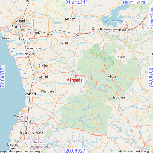
Vānsada GPS coordinates[2]
20° 45' 29.412" North, 73° 21' 50.004" East
| Map corner | latitude | longitude |
|---|---|---|
| Upper-left | 21.41421°, | 72.66077° |
| Center: | 20.75817°, | 73.36389° |
| Lower-right: | 20.09927°, | 74.06702° |
| Map W x H: | 146.2×146.2 km | = 90.8×90.8mi |
| max Lat: | 34.9274° ⇑62.7% North |
| Vānsada: | 20.75817° |
| min Lat: | ⇓37.3% South 8.09008° |
| min Long | Vānsada | max Long |
| 68.82655° | 73.36389° | 96.81° |
| W 6.9%⇐ | ⇒93.1% E |
Elevation
Elevation of Vānsada is 116 m = 381 ft, and this is 179.6 m = 589 ft below average elevation for this country.
| Max E: |
3681 m = 12077 ft | 65.6% |
| Avg. | 295.6 m = 970 ft | |
| Vānsada | 116 m = 381 ft | |
Min E: |
1 m = 3 ft | 34.4% |
See also: India elevation on elevation.city.
Geographical zone
Vānsada is located in North Torrid zone (between Equator and Tropic of Cancer). Distance of this Northern Tropic circle is 297.8 km =185 mi to North.| Distance of | km | miles | from Vānsada |
|---|---|---|---|
| North Pole | 7699 | 4783.9 | to North |
| Arctic Circle | 5093.1 | 3164.7 | to North |
| Tropic Cancer | 297.8 | 185 | to North |
| Equator | 2308.1 | 1434.2 | to South |


Nearby cities:
15 places around Vānsada: (largest is in red/bold)
• Abrama
48.8 km =30.3 mi,  283°
283°
• Ahwa
33.5 km =20.8 mi,  90°
90°
• Bilimora
41.9 km =26 mi,  271°
271°
• Bārdoli
48.3 km =30 mi,  327°
327°
• Chikhli
31.3 km =19.4 mi, 269°
• Dharampur
31.6 km =19.6 mi,  218°
218°
• Gandevi
38.5 km =23.9 mi, 278°
• Navsāri
50 km =31.1 mi,  294°
294°
• Parnera
48.5 km =30.1 mi,  243°
243°
• Pārdi
51.6 km =32.1 mi, 237°
• Songadh
50.2 km =31.2 mi,  24°
24°
• Surgāna
36 km =22.4 mi,  127°
127°
• Valsād
47.6 km =29.6 mi,  249°
249°
• Vyāra
39.3 km =24.4 mi,  4°
4°
• Waghāi
14.3 km =8.9 mi,  84°
84°
Sources, notices
• [Note1] Compared only with cities in India existing in our database
• [Src1] Map data: © OpenStreetMap contributors (CC-BY-SA)
• [Src2] Other city data from geonames.org with taken over terms of usage.
• [Src3] Geographical zone / Annual Mean Temperature by Robert A. Rohde @ Wikipedia
