Vadodara geodata
Vadodara (Gujarat) is a populated place; located in India in Asia/Kolkata (GMT+5.5) time zone. With population of 1,409,476 people, there are 20 cities with bigger population in this country. Compared to other cities in India, 54.5% of cities are located further ↑North; 93.7% of cities are located further →East and 80.5% of cities have higher elevation than Vadodara. Note1


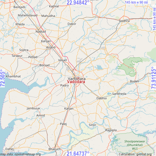
Vadodara GPS coordinates[2]
22° 17' 57.876" North, 73° 12' 29.232" East
| Map corner | latitude | longitude |
|---|---|---|
| Upper-left | 22.94842°, | 72.505° |
| Center: | 22.29941°, | 73.20812° |
| Lower-right: | 21.64737°, | 73.91125° |
| Map W x H: | 144.7×144.7 km | = 89.9×89.9mi |
| max Lat: | 34.9274° ⇑54.5% North |
| Vadodara: | 22.29941° |
| min Lat: | ⇓45.5% South 8.09008° |
| min Long | Vadodara | max Long |
| 68.82655° | 73.20812° | 96.81° |
| W 6.3%⇐ | ⇒93.7% E |
Elevation
Elevation of Vadodara is 46 m = 151 ft, and this is 249.6 m = 819 ft below average elevation for this country.
| Max E: |
3681 m = 12077 ft | 80.5% |
| Avg. | 295.6 m = 970 ft | |
| Vadodara | 46 m = 151 ft | |
Min E: |
1 m = 3 ft | 19.5% |
See also: Vadodara elevation on elevation.city.
Geographical zone
Vadodara is located in North Torrid zone (between Equator and Tropic of Cancer). Distance of this Northern Tropic circle is 126.5 km =78.6 mi to North.| Distance of | km | miles | from Vadodara |
|---|---|---|---|
| North Pole | 7527.6 | 4677.4 | to North |
| Arctic Circle | 4921.7 | 3058.2 | to North |
| Tropic Cancer | 126.5 | 78.6 | to North |
| Equator | 2479.5 | 1540.7 | to South |


Nearby cities:
15 places around Vadodara: (largest is in red/bold)
• Anand
38.3 km =23.8 mi,  317°
317°
• Borsad
34.1 km =21.2 mi,  290°
290°
• Dabhoi
26.5 km =16.5 mi,  119°
119°
• Dhuwaran
46.7 km =29 mi,  261°
261°
• Hālol
35.4 km =22 mi,  50°
50°
• Karamsad
41.3 km =25.7 mi,  310°
310°
• Kālol
43.1 km =26.8 mi,  37°
37°
• Padra
14.3 km =8.9 mi,  242°
242°
• Petlād
46.4 km =28.8 mi,  295°
295°
• Sankheda
40.7 km =25.3 mi,  110°
110°
• Shivrājpur
43.4 km =27 mi,  71°
71°
• Sinor
45.2 km =28.1 mi,  162°
162°
• Umreth
45.4 km =28.2 mi,  347°
347°
• Vallabh Vidyanagar
41 km =25.5 mi, 309°
• Vāghodia
19.8 km =12.3 mi,  88°
88°
Sources, notices
• [Note1] Compared only with cities in India existing in our database
• [Src1] Map data: © OpenStreetMap contributors (CC-BY-SA)
• [Src2] Other city data from geonames.org with taken over terms of usage.
• [Src3] Geographical zone / Annual Mean Temperature by Robert A. Rohde @ Wikipedia
