Vāghodia geodata
Vāghodia (Gujarat) is a populated place; located in India in Asia/Kolkata (GMT+5.5) time zone. With population of 14,606 people, there are 2501 cities with bigger population in this country. Compared to other cities in India, 54.4% of cities are located further ↑North; 92.9% of cities are located further →East and 78.3% of cities have higher elevation than Vāghodia. Note1


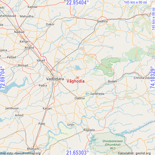
Vāghodia GPS coordinates[2]
22° 18' 18.18" North, 73° 24' 0.576" East
| Map corner | latitude | longitude |
|---|---|---|
| Upper-left | 22.95404°, | 72.69704° |
| Center: | 22.30505°, | 73.40016° |
| Lower-right: | 21.65303°, | 74.10329° |
| Map W x H: | 144.7×144.7 km | = 89.9×89.9mi |
| max Lat: | 34.9274° ⇑54.4% North |
| Vāghodia: | 22.30505° |
| min Lat: | ⇓45.6% South 8.09008° |
| min Long | Vāghodia | max Long |
| 68.82655° | 73.40016° | 96.81° |
| W 7.1%⇐ | ⇒92.9% E |
Elevation
Elevation of Vāghodia is 54 m = 177 ft, and this is 241.6 m = 793 ft below average elevation for this country.
| Max E: |
3681 m = 12077 ft | 78.3% |
| Avg. | 295.6 m = 970 ft | |
| Vāghodia | 54 m = 177 ft | |
Min E: |
1 m = 3 ft | 21.7% |
See also: India elevation on elevation.city.
Geographical zone
Vāghodia is located in North Torrid zone (between Equator and Tropic of Cancer). Distance of this Northern Tropic circle is 125.8 km =78.2 mi to North.| Distance of | km | miles | from Vāghodia |
|---|---|---|---|
| North Pole | 7527 | 4677.1 | to North |
| Arctic Circle | 4921.1 | 3057.8 | to North |
| Tropic Cancer | 125.8 | 78.2 | to North |
| Equator | 2480.1 | 1541.1 | to South |


Nearby cities:
15 places around Vāghodia: (largest is in red/bold)
• Anand
53.4 km =33.2 mi,  301°
301°
• Borsad
52.9 km =32.9 mi,  282°
282°
• Dabhoi
14 km =8.7 mi,  165°
165°
• Dākor
56 km =34.8 mi,  332°
332°
• Hālol
23.3 km =14.5 mi,  18°
18°
• Jetpur
45.5 km =28.3 mi,  84°
84°
• Kālol
34.3 km =21.3 mi,  10°
10°
• Padra
33.3 km =20.7 mi,  257°
257°
• Rājpīpla
49.8 km =30.9 mi, 168°
• Sankheda
23.7 km =14.7 mi,  129°
129°
• Shivrājpur
25.1 km =15.6 mi,  58°
58°
• Sinor
44.2 km =27.5 mi,  188°
188°
• Umreth
52.6 km =32.7 mi, 326°
• Vadodara
19.8 km =12.3 mi,  268°
268°
• Vejalpur
46 km =28.6 mi, 21°
Sources, notices
• [Note1] Compared only with cities in India existing in our database
• [Src1] Map data: © OpenStreetMap contributors (CC-BY-SA)
• [Src2] Other city data from geonames.org with taken over terms of usage.
• [Src3] Geographical zone / Annual Mean Temperature by Robert A. Rohde @ Wikipedia
