Sinor geodata
Sinor (Gujarat) is a populated place; located in India in Asia/Kolkata (GMT+5.5) time zone. With population of 11,267 people, there are 2807 cities with bigger population in this country. Compared to other cities in India, 56.9% of cities are located further ↑North; 93.2% of cities are located further →East and 83% of cities have higher elevation than Sinor. Note1


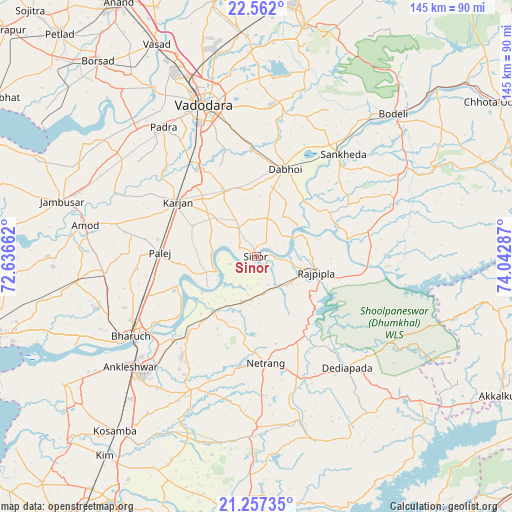
Sinor GPS coordinates[2]
21° 54' 40.212" North, 73° 20' 23.064" East
| Map corner | latitude | longitude |
|---|---|---|
| Upper-left | 22.562°, | 72.63662° |
| Center: | 21.91117°, | 73.33974° |
| Lower-right: | 21.25735°, | 74.04287° |
| Map W x H: | 145.1×145.1 km | = 90.2×90.2mi |
| max Lat: | 34.9274° ⇑56.9% North |
| Sinor: | 21.91117° |
| min Lat: | ⇓43.1% South 8.09008° |
| min Long | Sinor | max Long |
| 68.82655° | 73.33974° | 96.81° |
| W 6.8%⇐ | ⇒93.2% E |
Elevation
Elevation of Sinor is 37 m = 121 ft, and this is 258.6 m = 848 ft below average elevation for this country.
| Max E: |
3681 m = 12077 ft | 83% |
| Avg. | 295.6 m = 970 ft | |
| Sinor | 37 m = 121 ft | |
Min E: |
1 m = 3 ft | 17% |
See also: India elevation on elevation.city.
Geographical zone
Sinor is located in North Torrid zone (between Equator and Tropic of Cancer). Distance of this Northern Tropic circle is 169.6 km =105.4 mi to North.| Distance of | km | miles | from Sinor |
|---|---|---|---|
| North Pole | 7570.8 | 4704.3 | to North |
| Arctic Circle | 4964.9 | 3085 | to North |
| Tropic Cancer | 169.6 | 105.4 | to North |
| Equator | 2436.3 | 1513.8 | to South |


Nearby cities:
15 places around Sinor: (largest is in red/bold)
• Amod
49.2 km =30.6 mi,  280°
280°
• Ankleshwar
47.6 km =29.6 mi,  229°
229°
• Bharūch
44.2 km =27.5 mi,  237°
237°
• Dabhoi
31.8 km =19.8 mi,  17°
17°
• Dhuwaran
70 km =43.5 mi,  301°
301°
• Hansot
65.8 km =40.9 mi, 236°
• Hālol
67.2 km =41.8 mi,  11°
11°
• Jambusar
57.7 km =35.9 mi,  285°
285°
• Kosamba
63.6 km =39.5 mi,  218°
218°
• Padra
45 km =28 mi,  324°
324°
• Rājpīpla
17.3 km =10.7 mi,  106°
106°
• Sankheda
37.9 km =23.5 mi,  40°
40°
• Shivrājpur
63.3 km =39.3 mi,  25°
25°
• Vadodara
45.2 km =28.1 mi,  342°
342°
• Vāghodia
44.2 km =27.5 mi, 8°
Sources, notices
• [Note1] Compared only with cities in India existing in our database
• [Src1] Map data: © OpenStreetMap contributors (CC-BY-SA)
• [Src2] Other city data from geonames.org with taken over terms of usage.
• [Src3] Geographical zone / Annual Mean Temperature by Robert A. Rohde @ Wikipedia
