Padra geodata
Padra (Gujarat) is a populated place; located in India in Asia/Kolkata (GMT+5.5) time zone. With population of 36,499 people, there are 1201 cities with bigger population in this country. Compared to other cities in India, 54.8% of cities are located further ↑North; 94.3% of cities are located further →East and 83.9% of cities have higher elevation than Padra. Note1


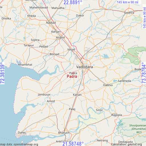
Padra GPS coordinates[2]
22° 14' 23.28" North, 73° 5' 4.236" East
| Map corner | latitude | longitude |
|---|---|---|
| Upper-left | 22.8891°, | 72.38139° |
| Center: | 22.2398°, | 73.08451° |
| Lower-right: | 21.58748°, | 73.78764° |
| Map W x H: | 144.7×144.7 km | = 89.9×89.9mi |
| max Lat: | 34.9274° ⇑54.8% North |
| Padra: | 22.2398° |
| min Lat: | ⇓45.2% South 8.09008° |
| min Long | Padra | max Long |
| 68.82655° | 73.08451° | 96.81° |
| W 5.7%⇐ | ⇒94.3% E |
Elevation
Elevation of Padra is 34 m = 112 ft, and this is 261.6 m = 858 ft below average elevation for this country.
| Max E: |
3681 m = 12077 ft | 83.9% |
| Avg. | 295.6 m = 970 ft | |
| Padra | 34 m = 112 ft | |
Min E: |
1 m = 3 ft | 16.1% |
See also: India elevation on elevation.city.
Geographical zone
Padra is located in North Torrid zone (between Equator and Tropic of Cancer). Distance of this Northern Tropic circle is 133.1 km =82.7 mi to North.| Distance of | km | miles | from Padra |
|---|---|---|---|
| North Pole | 7534.2 | 4681.5 | to North |
| Arctic Circle | 4928.3 | 3062.3 | to North |
| Tropic Cancer | 133.1 | 82.7 | to North |
| Equator | 2472.8 | 1536.5 | to South |


Nearby cities:
15 places around Padra: (largest is in red/bold)
• Amod
35.2 km =21.9 mi,  218°
218°
• Anand
37.2 km =23.1 mi,  339°
339°
• Borsad
26.8 km =16.7 mi,  314°
314°
• Chaklāsi
48.2 km =30 mi, 342°
• Dabhoi
36.5 km =22.7 mi,  99°
99°
• Dhuwaran
33.5 km =20.8 mi,  269°
269°
• Hālol
49.5 km =30.8 mi,  53°
53°
• Jambusar
35.9 km =22.3 mi,  234°
234°
• Karamsad
38.4 km =23.9 mi,  331°
331°
• Khambhāt
48.7 km =30.3 mi,  280°
280°
• Petlād
39.4 km =24.5 mi, 312°
• Sinor
45 km =28 mi,  144°
144°
• Vadodara
14.3 km =8.9 mi,  62°
62°
• Vallabh Vidyanagar
37.7 km =23.4 mi, 329°
• Vāghodia
33.3 km =20.7 mi,  77°
77°
Sources, notices
• [Note1] Compared only with cities in India existing in our database
• [Src1] Map data: © OpenStreetMap contributors (CC-BY-SA)
• [Src2] Other city data from geonames.org with taken over terms of usage.
• [Src3] Geographical zone / Annual Mean Temperature by Robert A. Rohde @ Wikipedia
