Udalguri geodata
Udalguri (Assam) is a populated place; located in India in Asia/Kolkata (GMT+5.5) time zone. With population of 15,935 people, there are 2375 cities with bigger population in this country. Compared to other cities in India, 76.5% of cities are located further ↓South; 97% of cities are located further ←West and 65.6% of cities have higher elevation than Udalguri. Note1


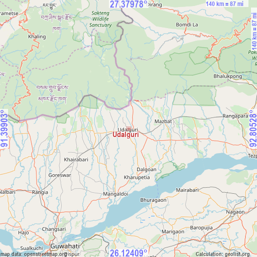
Udalguri GPS coordinates[2]
26° 45' 13.212" North, 92° 6' 7.74" East
| Map corner | latitude | longitude |
|---|---|---|
| Upper-left | 27.37978°, | 91.39903° |
| Center: | 26.75367°, | 92.10215° |
| Lower-right: | 26.12409°, | 92.80528° |
| Map W x H: | 139.6×139.6 km | = 86.7×86.7mi |
| max Lat: | 34.9274° ⇑23.5% North |
| Udalguri: | 26.75367° |
| min Lat: | ⇓76.5% South 8.09008° |
| min Long | Udalguri | max Long |
| 68.82655° | 92.10215° | 96.81° |
| W 97%⇐ | ⇒3% E |
Elevation
Elevation of Udalguri is 116 m = 381 ft, and this is 179.6 m = 589 ft below average elevation for this country.
| Max E: |
3681 m = 12077 ft | 65.6% |
| Avg. | 295.6 m = 970 ft | |
| Udalguri | 116 m = 381 ft | |
Min E: |
1 m = 3 ft | 34.4% |
See also: India elevation on elevation.city.
Geographical zone
Udalguri is located in North temperate zone (between Tropic of Cancer and the Arctic Circle). Distance of this Northern Tropic circle is 368.8 km =229.2 mi to South.| Distance of | km | miles | from Udalguri |
|---|---|---|---|
| North Pole | 7032.3 | 4369.7 | to North |
| Arctic Circle | 4426.4 | 2750.4 | to North |
| Tropic Cancer | 368.8 | 229.2 | to South |
| Equator | 2974.7 | 1848.4 | to South |


Nearby cities:
15 places around Udalguri: (largest is in red/bold)
• Bomdila
65.2 km =40.5 mi,  29°
29°
• Dhekiajuli
37.7 km =23.4 mi,  98°
98°
• Dhing
48.7 km =30.3 mi,  130°
130°
• Dispur
75 km =46.6 mi,  203°
203°
• Guwahati
72.6 km =45.1 mi,  209°
209°
• Hājo
80.6 km =50.1 mi,  225°
225°
• Khārupatia
26.5 km =16.5 mi,  170°
170°
• Mangaldai
35.4 km =22 mi,  191°
191°
• Morigaon
61.2 km =38 mi,  156°
156°
• Mushalpur
69.9 km =43.4 mi,  253°
253°
• North Guwāhāti
72.6 km =45.1 mi, 211°
• Rahā
71.1 km =44.2 mi,  144°
144°
• Rangia
59.2 km =36.8 mi,  235°
235°
• Rangāpāra
57 km =35.4 mi,  80°
80°
• Tezpur
70.6 km =43.9 mi, 100°
Sources, notices
• [Note1] Compared only with cities in India existing in our database
• [Src1] Map data: © OpenStreetMap contributors (CC-BY-SA)
• [Src2] Other city data from geonames.org with taken over terms of usage.
• [Src3] Geographical zone / Annual Mean Temperature by Robert A. Rohde @ Wikipedia
