Rahā geodata
Rahā (Assam) is a populated place; located in India in Asia/Kolkata (GMT+5.5) time zone. With population of 4,724 people, there are 3353 cities with bigger population in this country. Compared to other cities in India, 72.3% of cities are located further ↓South; 97.3% of cities are located further ←West and 75.9% of cities have higher elevation than Rahā. Note1


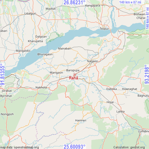
Rahā GPS coordinates[2]
26° 13' 59.988" North, 92° 31' 0.012" East
| Map corner | latitude | longitude |
|---|---|---|
| Upper-left | 26.86231°, | 91.81355° |
| Center: | 26.23333°, | 92.51667° |
| Lower-right: | 25.60093°, | 93.2198° |
| Map W x H: | 140.3×140.3 km | = 87.2×87.2mi |
| max Lat: | 34.9274° ⇑27.7% North |
| Rahā: | 26.23333° |
| min Lat: | ⇓72.3% South 8.09008° |
| min Long | Rahā | max Long |
| 68.82655° | 92.51667° | 96.81° |
| W 97.3%⇐ | ⇒2.7% E |
Elevation
Elevation of Rahā is 64 m = 210 ft, and this is 231.6 m = 760 ft below average elevation for this country.
| Max E: |
3681 m = 12077 ft | 75.9% |
| Avg. | 295.6 m = 970 ft | |
| Rahā | 64 m = 210 ft | |
Min E: |
1 m = 3 ft | 24.1% |
See also: India elevation on elevation.city.
Geographical zone
Rahā is located in North temperate zone (between Tropic of Cancer and the Arctic Circle). Distance of this Northern Tropic circle is 311 km =193.2 mi to South.| Distance of | km | miles | from Rahā |
|---|---|---|---|
| North Pole | 7090.2 | 4405.6 | to North |
| Arctic Circle | 4484.3 | 2786.4 | to North |
| Tropic Cancer | 311 | 193.2 | to South |
| Equator | 2916.9 | 1812.5 | to South |


Nearby cities:
15 places around Rahā: (largest is in red/bold)
• Biswanath Chariali
83.2 km =51.7 mi,  48°
48°
• Dhekiajuli
52.4 km =32.6 mi,  355°
355°
• Dhing
26.4 km =16.4 mi,  350°
350°
• Dispur
72.3 km =44.9 mi,  261°
261°
• Guwahati
77.1 km =47.9 mi,  265°
265°
• Hamren
34.8 km =21.6 mi,  163°
163°
• Hojāi
42.5 km =26.4 mi,  127°
127°
• Khārupatia
48.6 km =30.2 mi,  310°
310°
• Mangaldai
53.7 km =33.4 mi,  295°
295°
• Morigaon
16.9 km =10.5 mi,  275°
275°
• Nongpoh
73.7 km =45.8 mi,  240°
240°
• North Guwāhāti
79.5 km =49.4 mi, 267°
• Rangāpāra
68.9 km =42.8 mi,  12°
12°
• Tezpur
52.7 km =32.7 mi,  32°
32°
• Udalguri
71.1 km =44.2 mi,  324°
324°
Sources, notices
• [Note1] Compared only with cities in India existing in our database
• [Src1] Map data: © OpenStreetMap contributors (CC-BY-SA)
• [Src2] Other city data from geonames.org with taken over terms of usage.
• [Src3] Geographical zone / Annual Mean Temperature by Robert A. Rohde @ Wikipedia
