Bomdila geodata
Bomdila (Arunachal Pradesh) is a populated place; located in India in Asia/Kolkata (GMT+5.5) time zone. With population of 7,121 people, there are 3204 cities with bigger population in this country. Compared to other cities in India, 80.5% of cities are located further ↓South; 97.2% of cities are located further ←West and 99.7% of cities have lower elevation than Bomdila. Note1


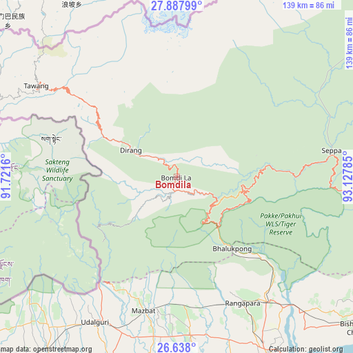
Bomdila GPS coordinates[2]
27° 15' 53.1" North, 92° 25' 28.992" East
| Map corner | latitude | longitude |
|---|---|---|
| Upper-left | 27.88799°, | 91.7216° |
| Center: | 27.26475°, | 92.42472° |
| Lower-right: | 26.638°, | 93.12785° |
| Map W x H: | 139×139 km | = 86.4×86.4mi |
| max Lat: | 34.9274° ⇑19.5% North |
| Bomdila: | 27.26475° |
| min Lat: | ⇓80.5% South 8.09008° |
| min Long | Bomdila | max Long |
| 68.82655° | 92.42472° | 96.81° |
| W 97.2%⇐ | ⇒2.8% E |
Elevation
Elevation of Bomdila is 2507 m = 8225 ft, and this is 2211.4 m = 7255 ft above average elevation for this country.
| Max E: |
3681 m = 12077 ft | 0.3% |
| Bomdila | 2507 m 8225 ft | |
| Avg. | 295.6 m = 970 ft | |
Min E: |
1 m = 3 ft | 99.7% |
See also: India elevation on elevation.city.
Geographical zone
Bomdila is located in North temperate zone (between Tropic of Cancer and the Arctic Circle). Distance of this Northern Tropic circle is 425.6 km =264.5 mi to South.| Distance of | km | miles | from Bomdila |
|---|---|---|---|
| North Pole | 6975.5 | 4334.4 | to North |
| Arctic Circle | 4369.6 | 2715.1 | to North |
| Tropic Cancer | 425.6 | 264.5 | to South |
| Equator | 3031.6 | 1883.7 | to South |


Nearby cities:
15 places around Bomdila: (largest is in red/bold)
• Biswanath Chariali
93.3 km =58 mi,  129°
129°
• Dhekiajuli
62.6 km =38.9 mi,  175°
175°
• Dhing
88.7 km =55.1 mi, 176°
• Gohpur
125.4 km =77.9 mi,  109°
109°
• Itānagar
118.9 km =73.9 mi,  99°
99°
• Khārupatia
87.4 km =54.3 mi,  198°
198°
• Mangaldai
99.5 km =61.8 mi, 203°
• Morigaon
113.2 km =70.3 mi, 183°
• Mushalpur
124.9 km =77.6 mi,  232°
232°
• Rahā
115 km =71.5 mi, 175°
• Rangia
121.2 km =75.3 mi,  221°
221°
• Rangāpāra
53.3 km =33.1 mi,  153°
153°
• Tawang
60.2 km =37.4 mi,  304°
304°
• Tezpur
79.5 km =49.4 mi, 152°
• Udalguri
65.2 km =40.5 mi,  209°
209°
Sources, notices
• [Note1] Compared only with cities in India existing in our database
• [Src1] Map data: © OpenStreetMap contributors (CC-BY-SA)
• [Src2] Other city data from geonames.org with taken over terms of usage.
• [Src3] Geographical zone / Annual Mean Temperature by Robert A. Rohde @ Wikipedia
