Tezpur geodata
Tezpur (Assam) is a populated place; located in India in Asia/Kolkata (GMT+5.5) time zone. With population of 58,851 people, there are 747 cities with bigger population in this country. Compared to other cities in India, 75.6% of cities are located further ↓South; 97.7% of cities are located further ←West and 73.8% of cities have higher elevation than Tezpur. Note1


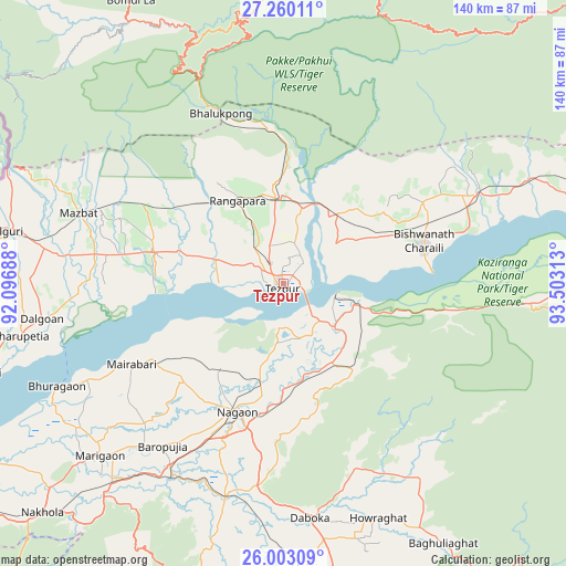
Tezpur GPS coordinates[2]
26° 37' 59.988" North, 92° 48' 0" East
| Map corner | latitude | longitude |
|---|---|---|
| Upper-left | 27.26011°, | 92.09688° |
| Center: | 26.63333°, | 92.8° |
| Lower-right: | 26.00309°, | 93.50313° |
| Map W x H: | 139.8×139.8 km | = 86.9×86.9mi |
| max Lat: | 34.9274° ⇑24.4% North |
| Tezpur: | 26.63333° |
| min Lat: | ⇓75.6% South 8.09008° |
| min Long | Tezpur | max Long |
| 68.82655° | 92.8° | 96.81° |
| W 97.7%⇐ | ⇒2.3% E |
Elevation
Elevation of Tezpur is 74 m = 243 ft, and this is 221.6 m = 727 ft below average elevation for this country.
| Max E: |
3681 m = 12077 ft | 73.8% |
| Avg. | 295.6 m = 970 ft | |
| Tezpur | 74 m = 243 ft | |
Min E: |
1 m = 3 ft | 26.2% |
See also: Tezpur elevation on elevation.city.
Geographical zone
Tezpur is located in North temperate zone (between Tropic of Cancer and the Arctic Circle). Distance of this Northern Tropic circle is 355.4 km =220.8 mi to South.| Distance of | km | miles | from Tezpur |
|---|---|---|---|
| North Pole | 7045.7 | 4378 | to North |
| Arctic Circle | 4439.8 | 2758.8 | to North |
| Tropic Cancer | 355.4 | 220.8 | to South |
| Equator | 2961.3 | 1840.1 | to South |


Nearby cities:
15 places around Tezpur: (largest is in red/bold)
• Biswanath Chariali
35.9 km =22.3 mi,  73°
73°
• Bokākhāt
79.6 km =49.5 mi,  89°
89°
• Bomdila
79.5 km =49.4 mi,  332°
332°
• Dhekiajuli
32.9 km =20.4 mi,  283°
283°
• Dhing
37.3 km =23.2 mi,  240°
240°
• Gohpur
85.6 km =53.2 mi, 71°
• Hamren
79.9 km =49.6 mi,  193°
193°
• Hojāi
70.3 km =43.7 mi,  175°
175°
• Khārupatia
66.2 km =41.1 mi,  258°
258°
• Mangaldai
79.4 km =49.3 mi,  254°
254°
• Morigaon
62.1 km =38.6 mi,  226°
226°
• Numāligarh
91.7 km =57 mi, 90°
• Rahā
52.7 km =32.7 mi,  212°
212°
• Rangāpāra
26.2 km =16.3 mi, 330°
• Udalguri
70.6 km =43.9 mi, 280°
Sources, notices
• [Note1] Compared only with cities in India existing in our database
• [Src1] Map data: © OpenStreetMap contributors (CC-BY-SA)
• [Src2] Other city data from geonames.org with taken over terms of usage.
• [Src3] Geographical zone / Annual Mean Temperature by Robert A. Rohde @ Wikipedia
