Mangaldai geodata
Mangaldai (Assam) is a populated place; located in India in Asia/Kolkata (GMT+5.5) time zone. With population of 24,871 people, there are 1715 cities with bigger population in this country. Compared to other cities in India, 74% of cities are located further ↓South; 97% of cities are located further ←West and 76.3% of cities have higher elevation than Mangaldai. Note1


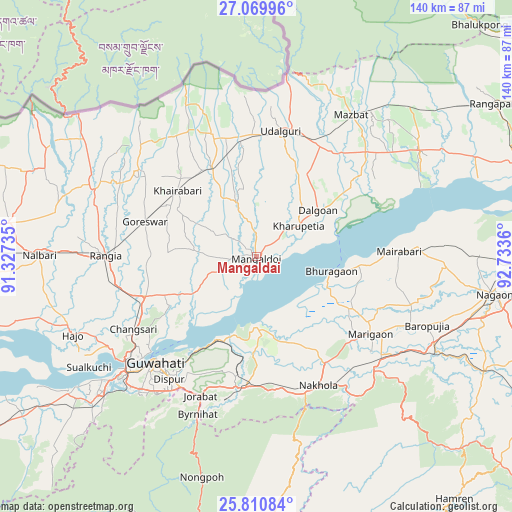
Mangaldai GPS coordinates[2]
26° 26' 31.632" North, 92° 1' 49.692" East
| Map corner | latitude | longitude |
|---|---|---|
| Upper-left | 27.06996°, | 91.32735° |
| Center: | 26.44212°, | 92.03047° |
| Lower-right: | 25.81084°, | 92.7336° |
| Map W x H: | 140×140 km | = 87×87mi |
| max Lat: | 34.9274° ⇑26% North |
| Mangaldai: | 26.44212° |
| min Lat: | ⇓74% South 8.09008° |
| min Long | Mangaldai | max Long |
| 68.82655° | 92.03047° | 96.81° |
| W 97%⇐ | ⇒3% E |
Elevation
Elevation of Mangaldai is 62 m = 203 ft, and this is 233.6 m = 766 ft below average elevation for this country.
| Max E: |
3681 m = 12077 ft | 76.3% |
| Avg. | 295.6 m = 970 ft | |
| Mangaldai | 62 m = 203 ft | |
Min E: |
1 m = 3 ft | 23.7% |
See also: India elevation on elevation.city.
Geographical zone
Mangaldai is located in North temperate zone (between Tropic of Cancer and the Arctic Circle). Distance of this Northern Tropic circle is 334.2 km =207.7 mi to South.| Distance of | km | miles | from Mangaldai |
|---|---|---|---|
| North Pole | 7067 | 4391.2 | to North |
| Arctic Circle | 4461.1 | 2772 | to North |
| Tropic Cancer | 334.2 | 207.7 | to South |
| Equator | 2940.1 | 1826.9 | to South |


Nearby cities:
15 places around Mangaldai: (largest is in red/bold)
• Dhekiajuli
53.2 km =33.1 mi,  56°
56°
• Dhing
44.2 km =27.5 mi,  86°
86°
• Dispur
41.1 km =25.5 mi,  213°
213°
• Guwahati
40.3 km =25 mi,  224°
224°
• Hājo
54.9 km =34.1 mi,  246°
246°
• Khārupatia
14.4 km =8.9 mi,  53°
53°
• Morigaon
38.2 km =23.7 mi,  124°
124°
• Mushalpur
62 km =38.5 mi,  284°
284°
• Nongpoh
61.9 km =38.5 mi,  194°
194°
• North Guwāhāti
41.2 km =25.6 mi,  228°
228°
• Palāsbāri
60.4 km =37.5 mi, 234°
• Rahā
53.7 km =33.4 mi, 115°
• Rangia
41.5 km =25.8 mi,  271°
271°
• Soalkuchi
55 km =34.2 mi,  236°
236°
• Udalguri
35.4 km =22 mi,  11°
11°
Sources, notices
• [Note1] Compared only with cities in India existing in our database
• [Src1] Map data: © OpenStreetMap contributors (CC-BY-SA)
• [Src2] Other city data from geonames.org with taken over terms of usage.
• [Src3] Geographical zone / Annual Mean Temperature by Robert A. Rohde @ Wikipedia
