North Guwāhāti geodata
North Guwāhāti (Assam) is a populated place; located in India in Asia/Kolkata (GMT+5.5) time zone. With population of 17,516 people, there are 2236 cities with bigger population in this country. Compared to other cities in India, 71.9% of cities are located further ↓South; 96.7% of cities are located further ←West and 77.5% of cities have higher elevation than North Guwāhāti. Note1


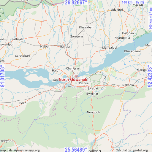
North Guwāhāti GPS coordinates[2]
26° 11' 50.964" North, 91° 43' 12.72" East
| Map corner | latitude | longitude |
|---|---|---|
| Upper-left | 26.82667°, | 91.01708° |
| Center: | 26.19749°, | 91.7202° |
| Lower-right: | 25.56489°, | 92.42333° |
| Map W x H: | 140.3×140.3 km | = 87.2×87.2mi |
| max Lat: | 34.9274° ⇑28.1% North |
| North Guwāhāti: | 26.19749° |
| min Lat: | ⇓71.9% South 8.09008° |
| min Long | North Guwāhāt | max Long |
| 68.82655° | 91.7202° | 96.81° |
| W 96.7%⇐ | ⇒3.3% E |
Elevation
Elevation of North Guwāhāti is 57 m = 187 ft, and this is 238.6 m = 783 ft below average elevation for this country.
| Max E: |
3681 m = 12077 ft | 77.5% |
| Avg. | 295.6 m = 970 ft | |
| North Guwāhāti | 57 m = 187 ft | |
Min E: |
1 m = 3 ft | 22.5% |
See also: India elevation on elevation.city.
Geographical zone
North Guwāhāti is located in North temperate zone (between Tropic of Cancer and the Arctic Circle). Distance of this Northern Tropic circle is 307 km =190.8 mi to South.| Distance of | km | miles | from North Guwāhāti |
|---|---|---|---|
| North Pole | 7094.2 | 4408.1 | to North |
| Arctic Circle | 4488.3 | 2788.9 | to North |
| Tropic Cancer | 307 | 190.8 | to South |
| Equator | 2912.9 | 1810 | to South |


Nearby cities:
15 places around North Guwāhāti: (largest is in red/bold)
• Barpeta
72.5 km =45 mi,  281°
281°
• Dispur
10.6 km =6.6 mi,  130°
130°
• Guwahati
2.9 km =1.8 mi,  119°
119°
• Hājo
20.2 km =12.6 mi,  285°
285°
• Khārupatia
55.5 km =34.5 mi,  50°
50°
• Mairang
71.2 km =44.2 mi,  186°
186°
• Mangaldai
41.2 km =25.6 mi, 48°
• Morigaon
62.8 km =39 mi,  84°
84°
• Mushalpur
51.6 km =32.1 mi,  325°
325°
• Nongpoh
36.4 km =22.6 mi,  154°
154°
• Palāsbāri
19.8 km =12.3 mi,  245°
245°
• Rangia
29.9 km =18.6 mi,  339°
339°
• Shillong
71.8 km =44.6 mi,  166°
166°
• Soalkuchi
15.2 km =9.4 mi,  257°
257°
• Udalguri
72.6 km =45.1 mi,  31°
31°
Sources, notices
• [Note1] Compared only with cities in India existing in our database
• [Src1] Map data: © OpenStreetMap contributors (CC-BY-SA)
• [Src2] Other city data from geonames.org with taken over terms of usage.
• [Src3] Geographical zone / Annual Mean Temperature by Robert A. Rohde @ Wikipedia
