Hājo geodata
Hājo (Assam) is a populated place; located in India in Asia/Kolkata (GMT+5.5) time zone. With population of 15,977 people, there are 2370 cities with bigger population in this country. Compared to other cities in India, 72.4% of cities are located further ↓South; 96.4% of cities are located further ←West and 77.2% of cities have higher elevation than Hājo. Note1


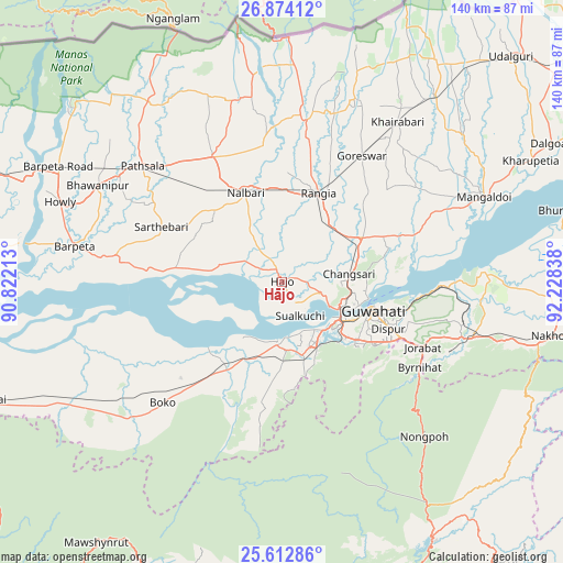
Hājo GPS coordinates[2]
26° 14' 42.72" North, 91° 31' 30.9" East
| Map corner | latitude | longitude |
|---|---|---|
| Upper-left | 26.87412°, | 90.82213° |
| Center: | 26.2452°, | 91.52525° |
| Lower-right: | 25.61286°, | 92.22838° |
| Map W x H: | 140.2×140.2 km | = 87.1×87.1mi |
| max Lat: | 34.9274° ⇑27.6% North |
| Hājo: | 26.2452° |
| min Lat: | ⇓72.4% South 8.09008° |
| min Long | Hājo | max Long |
| 68.82655° | 91.52525° | 96.81° |
| W 96.4%⇐ | ⇒3.6% E |
Elevation
Elevation of Hājo is 58 m = 190 ft, and this is 237.6 m = 780 ft below average elevation for this country.
| Max E: |
3681 m = 12077 ft | 77.2% |
| Avg. | 295.6 m = 970 ft | |
| Hājo | 58 m = 190 ft | |
Min E: |
1 m = 3 ft | 22.8% |
See also: India elevation on elevation.city.
Geographical zone
Hājo is located in North temperate zone (between Tropic of Cancer and the Arctic Circle). Distance of this Northern Tropic circle is 312.3 km =194.1 mi to South.| Distance of | km | miles | from Hājo |
|---|---|---|---|
| North Pole | 7088.9 | 4404.8 | to North |
| Arctic Circle | 4483 | 2785.6 | to North |
| Tropic Cancer | 312.3 | 194.1 | to South |
| Equator | 2918.2 | 1813.3 | to South |


Nearby cities:
15 places around Hājo: (largest is in red/bold)
• Barpeta
52.5 km =32.6 mi,  279°
279°
• Barpeta Road
62.3 km =38.7 mi,  297°
297°
• Dispur
30.1 km =18.7 mi,  113°
113°
• Guwahati
23 km =14.3 mi, 107°
• Howli
57.8 km =35.9 mi,  289°
289°
• Khārupatia
69 km =42.9 mi,  63°
63°
• Mairang
76.8 km =47.7 mi,  171°
171°
• Mangaldai
54.9 km =34.1 mi,  66°
66°
• Mushalpur
38.4 km =23.9 mi,  345°
345°
• Nongpoh
51.8 km =32.2 mi,  137°
137°
• North Guwāhāti
20.2 km =12.6 mi, 105°
• Palāsbāri
13.6 km =8.5 mi, 173°
• Rangia
24.3 km =15.1 mi,  21°
21°
• Soalkuchi
9.7 km =6 mi,  151°
151°
• Sorbhog
69.1 km =42.9 mi, 292°
Sources, notices
• [Note1] Compared only with cities in India existing in our database
• [Src1] Map data: © OpenStreetMap contributors (CC-BY-SA)
• [Src2] Other city data from geonames.org with taken over terms of usage.
• [Src3] Geographical zone / Annual Mean Temperature by Robert A. Rohde @ Wikipedia
