Sultanpur geodata
Sultanpur (Punjab) is a populated place; located in India in Asia/Kolkata (GMT+5.5) time zone. With population of 16,344 people, there are 2344 cities with bigger population in this country. Compared to other cities in India, 96.4% of cities are located further ↓South; 81% of cities are located further →East and 52.8% of cities have lower elevation than Sultanpur. Note1


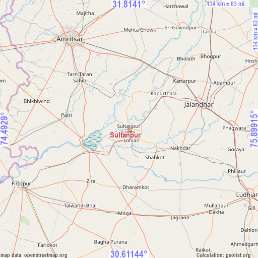
Sultanpur GPS coordinates[2]
31° 12' 52.848" North, 75° 11' 45.672" East
| Map corner | latitude | longitude |
|---|---|---|
| Upper-left | 31.8141°, | 74.4929° |
| Center: | 31.21468°, | 75.19602° |
| Lower-right: | 30.61144°, | 75.89915° |
| Map W x H: | 133.7×133.7 km | = 83.1×83.1mi |
| max Lat: | 34.9274° ⇑3.6% North |
| Sultanpur: | 31.21468° |
| min Lat: | ⇓96.4% South 8.09008° |
| min Long | Sultanpur | max Long |
| 68.82655° | 75.19602° | 96.81° |
| W 19%⇐ | ⇒81% E |
Elevation
Elevation of Sultanpur is 217 m = 712 ft, and this is 78.6 m = 258 ft below average elevation for this country.
| Max E: |
3681 m = 12077 ft | 47.2% |
| Avg. | 295.6 m = 970 ft | |
| Sultanpur | 217 m = 712 ft | |
Min E: |
1 m = 3 ft | 52.8% |
See also: India elevation on elevation.city.
Geographical zone
Sultanpur is located in North temperate zone (between Tropic of Cancer and the Arctic Circle). Distance of this Northern Tropic circle is 864.8 km =537.4 mi to South.| Distance of | km | miles | from Sultanpur |
|---|---|---|---|
| North Pole | 6536.3 | 4061.5 | to North |
| Arctic Circle | 3930.4 | 2442.2 | to North |
| Tropic Cancer | 864.8 | 537.4 | to South |
| Equator | 3470.7 | 2156.6 | to South |


Nearby cities:
15 places around Sultanpur: (largest is in red/bold)
• Dhilwan
36.2 km =22.5 mi,  23°
23°
• Jalandhar
38.4 km =23.9 mi,  71°
71°
• Jandiāla
40.6 km =25.2 mi,  98°
98°
• Jandiāla Gurū
41.8 km =26 mi,  337°
337°
• Kapūrthala
25.4 km =15.8 mi,  43°
43°
• Kartārpur
38.3 km =23.8 mi,  48°
48°
• Kot Īsa Khān
30.3 km =18.8 mi,  190°
190°
• Makhu
22.7 km =14.1 mi,  236°
236°
• Moga
44.6 km =27.7 mi,  183°
183°
• Nakodar
28.3 km =17.6 mi,  110°
110°
• Nūrmahal
40.1 km =24.9 mi, 109°
• Patti
32.9 km =20.4 mi,  282°
282°
• Shāhkot
20 km =12.4 mi,  137°
137°
• Tarn Tāran
36.7 km =22.8 mi,  315°
315°
• Zira
33.6 km =20.9 mi,  215°
215°
Sources, notices
• [Note1] Compared only with cities in India existing in our database
• [Src1] Map data: © OpenStreetMap contributors (CC-BY-SA)
• [Src2] Other city data from geonames.org with taken over terms of usage.
• [Src3] Geographical zone / Annual Mean Temperature by Robert A. Rohde @ Wikipedia
