Patti geodata
Patti (Punjab) is a populated place; located in India in Asia/Kolkata (GMT+5.5) time zone. With population of 37,087 people, there are 1183 cities with bigger population in this country. Compared to other cities in India, 96.5% of cities are located further ↓South; 83.9% of cities are located further →East and 53.3% of cities have lower elevation than Patti. Note1


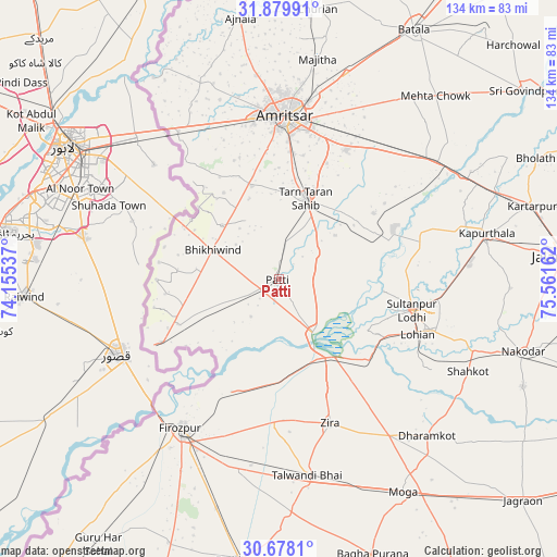
Patti GPS coordinates[2]
31° 16' 51.312" North, 74° 51' 30.564" East
| Map corner | latitude | longitude |
|---|---|---|
| Upper-left | 31.87991°, | 74.15537° |
| Center: | 31.28092°, | 74.85849° |
| Lower-right: | 30.6781°, | 75.56162° |
| Map W x H: | 133.6×133.6 km | = 83×83mi |
| max Lat: | 34.9274° ⇑3.5% North |
| Patti: | 31.28092° |
| min Lat: | ⇓96.5% South 8.09008° |
| min Long | Patti | max Long |
| 68.82655° | 74.85849° | 96.81° |
| W 16.1%⇐ | ⇒83.9% E |
Elevation
Elevation of Patti is 219 m = 719 ft, and this is 76.6 m = 251 ft below average elevation for this country.
| Max E: |
3681 m = 12077 ft | 46.7% |
| Avg. | 295.6 m = 970 ft | |
| Patti | 219 m = 719 ft | |
Min E: |
1 m = 3 ft | 53.3% |
See also: India elevation on elevation.city.
Geographical zone
Patti is located in North temperate zone (between Tropic of Cancer and the Arctic Circle). Distance of this Northern Tropic circle is 872.2 km =542 mi to South.| Distance of | km | miles | from Patti |
|---|---|---|---|
| North Pole | 6528.9 | 4056.9 | to North |
| Arctic Circle | 3923.1 | 2437.7 | to North |
| Tropic Cancer | 872.2 | 542 | to South |
| Equator | 3478.1 | 2161.2 | to South |


Nearby cities:
15 places around Patti: (largest is in red/bold)
• Amritsar
38 km =23.6 mi,  2°
2°
• Dhilwan
53 km =32.9 mi,  60°
60°
• Ferozepore
45.9 km =28.5 mi,  210°
210°
• Jandiāla Gurū
35.1 km =21.8 mi,  27°
27°
• Kapūrthala
50.8 km =31.6 mi,  77°
77°
• Khem Karan
32.2 km =20 mi,  241°
241°
• Kot Īsa Khān
45.7 km =28.4 mi,  144°
144°
• Majītha
53.8 km =33.4 mi,  10°
10°
• Makhu
23.7 km =14.7 mi,  146°
146°
• Rāja Sānsi
49.1 km =30.5 mi,  353°
353°
• Shāhkot
50.6 km =31.4 mi,  115°
115°
• Sultanpur
32.9 km =20.4 mi,  102°
102°
• Talwandi Bhai
47.7 km =29.6 mi,  171°
171°
• Tarn Tāran
20.1 km =12.5 mi,  19°
19°
• Zira
37 km =23 mi,  160°
160°
Sources, notices
• [Note1] Compared only with cities in India existing in our database
• [Src1] Map data: © OpenStreetMap contributors (CC-BY-SA)
• [Src2] Other city data from geonames.org with taken over terms of usage.
• [Src3] Geographical zone / Annual Mean Temperature by Robert A. Rohde @ Wikipedia
