Moga geodata
Moga (Punjab) is a populated place; located in India in Asia/Kolkata (GMT+5.5) time zone. With population of 130,549 people, there are 336 cities with bigger population in this country. Compared to other cities in India, 95.2% of cities are located further ↓South; 81.2% of cities are located further →East and 54.8% of cities have lower elevation than Moga. Note1


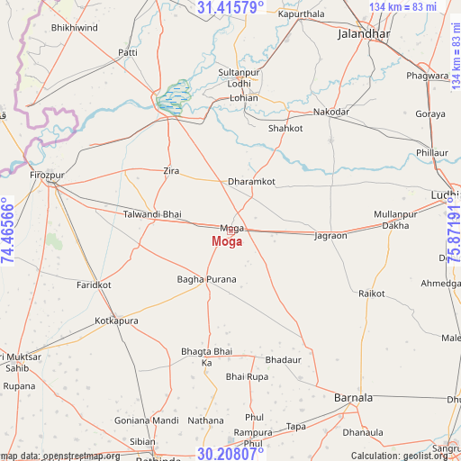
Moga GPS coordinates[2]
30° 48' 49.788" North, 75° 10' 7.608" East
| Map corner | latitude | longitude |
|---|---|---|
| Upper-left | 31.41579°, | 74.46566° |
| Center: | 30.81383°, | 75.16878° |
| Lower-right: | 30.20807°, | 75.87191° |
| Map W x H: | 134.3×134.3 km | = 83.5×83.5mi |
| max Lat: | 34.9274° ⇑4.8% North |
| Moga: | 30.81383° |
| min Lat: | ⇓95.2% South 8.09008° |
| min Long | Moga | max Long |
| 68.82655° | 75.16878° | 96.81° |
| W 18.8%⇐ | ⇒81.2% E |
Elevation
Elevation of Moga is 226 m = 741 ft, and this is 69.6 m = 228 ft below average elevation for this country.
| Max E: |
3681 m = 12077 ft | 45.2% |
| Avg. | 295.6 m = 970 ft | |
| Moga | 226 m = 741 ft | |
Min E: |
1 m = 3 ft | 54.8% |
See also: Moga elevation on elevation.city.
Geographical zone
Moga is located in North temperate zone (between Tropic of Cancer and the Arctic Circle). Distance of this Northern Tropic circle is 820.3 km =509.7 mi to South.| Distance of | km | miles | from Moga |
|---|---|---|---|
| North Pole | 6580.9 | 4089.2 | to North |
| Arctic Circle | 3975 | 2469.9 | to North |
| Tropic Cancer | 820.3 | 509.7 | to South |
| Equator | 3426.2 | 2128.9 | to South |


Nearby cities:
15 places around Moga: (largest is in red/bold)
• Badhni Kalān
18.8 km =11.7 mi,  141°
141°
• Bhadaur
40.6 km =25.2 mi,  157°
157°
• Bāgha Purāna
15.5 km =9.6 mi,  205°
205°
• Farīdkot
42.4 km =26.3 mi,  248°
248°
• Jagraon
29.3 km =18.2 mi,  95°
95°
• Jaito
48.2 km =30 mi, 213°
• Kot Īsa Khān
15.1 km =9.4 mi,  348°
348°
• Kotkapura
41.2 km =25.6 mi,  231°
231°
• Makhu
36.1 km =22.4 mi,  332°
332°
• Nakodar
45.3 km =28.1 mi,  40°
40°
• Rāikot
45.1 km =28 mi,  113°
113°
• Shāhkot
33.8 km =21 mi,  28°
28°
• Sultanpur
44.6 km =27.7 mi,  3°
3°
• Talwandi Bhai
23.3 km =14.5 mi,  281°
281°
• Zira
24.2 km =15 mi,  315°
315°
Sources, notices
• [Note1] Compared only with cities in India existing in our database
• [Src1] Map data: © OpenStreetMap contributors (CC-BY-SA)
• [Src2] Other city data from geonames.org with taken over terms of usage.
• [Src3] Geographical zone / Annual Mean Temperature by Robert A. Rohde @ Wikipedia
