Makhu geodata
Makhu (Punjab) is a populated place; located in India in Asia/Kolkata (GMT+5.5) time zone. With population of 12,886 people, there are 2663 cities with bigger population in this country. Compared to other cities in India, 96% of cities are located further ↓South; 82.8% of cities are located further →East and 51.9% of cities have lower elevation than Makhu. Note1


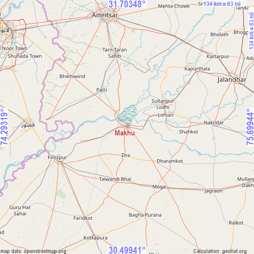
Makhu GPS coordinates[2]
31° 6' 12.06" North, 74° 59' 46.716" East
| Map corner | latitude | longitude |
|---|---|---|
| Upper-left | 31.70348°, | 74.29319° |
| Center: | 31.10335°, | 74.99631° |
| Lower-right: | 30.49941°, | 75.69944° |
| Map W x H: | 133.9×133.9 km | = 83.2×83.2mi |
| max Lat: | 34.9274° ⇑4% North |
| Makhu: | 31.10335° |
| min Lat: | ⇓96% South 8.09008° |
| min Long | Makhu | max Long |
| 68.82655° | 74.99631° | 96.81° |
| W 17.2%⇐ | ⇒82.8% E |
Elevation
Elevation of Makhu is 213 m = 699 ft, and this is 82.6 m = 271 ft below average elevation for this country.
| Max E: |
3681 m = 12077 ft | 48.1% |
| Avg. | 295.6 m = 970 ft | |
| Makhu | 213 m = 699 ft | |
Min E: |
1 m = 3 ft | 51.9% |
See also: India elevation on elevation.city.
Geographical zone
Makhu is located in North temperate zone (between Tropic of Cancer and the Arctic Circle). Distance of this Northern Tropic circle is 852.4 km =529.7 mi to South.| Distance of | km | miles | from Makhu |
|---|---|---|---|
| North Pole | 6548.7 | 4069.2 | to North |
| Arctic Circle | 3942.8 | 2449.9 | to North |
| Tropic Cancer | 852.4 | 529.7 | to South |
| Equator | 3458.4 | 2148.9 | to South |


Nearby cities:
15 places around Makhu: (largest is in red/bold)
• Bāgha Purāna
47.2 km =29.3 mi,  168°
168°
• Farīdkot
53 km =32.9 mi,  205°
205°
• Ferozepore
41.5 km =25.8 mi,  241°
241°
• Jandiāla Gurū
51.1 km =31.8 mi,  3°
3°
• Kapūrthala
47.8 km =29.7 mi,  49°
49°
• Khem Karan
41.8 km =26 mi,  276°
276°
• Kot Īsa Khān
22 km =13.7 mi,  142°
142°
• Moga
36.1 km =22.4 mi,  152°
152°
• Nakodar
45.6 km =28.3 mi,  86°
86°
• Patti
23.7 km =14.7 mi,  326°
326°
• Shāhkot
32.5 km =20.2 mi, 94°
• Sultanpur
22.7 km =14.1 mi,  56°
56°
• Talwandi Bhai
28.2 km =17.5 mi,  192°
192°
• Tarn Tāran
39.3 km =24.4 mi,  350°
350°
• Zira
15 km =9.3 mi,  181°
181°
Sources, notices
• [Note1] Compared only with cities in India existing in our database
• [Src1] Map data: © OpenStreetMap contributors (CC-BY-SA)
• [Src2] Other city data from geonames.org with taken over terms of usage.
• [Src3] Geographical zone / Annual Mean Temperature by Robert A. Rohde @ Wikipedia
