Nakodar geodata
Nakodar (Punjab) is a populated place; located in India in Asia/Kolkata (GMT+5.5) time zone. With population of 32,405 people, there are 1343 cities with bigger population in this country. Compared to other cities in India, 96.2% of cities are located further ↓South; 78.7% of cities are located further →East and 57.1% of cities have lower elevation than Nakodar. Note1


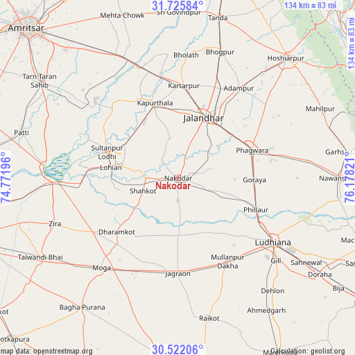
Nakodar GPS coordinates[2]
31° 7' 33.096" North, 75° 28' 30.288" East
| Map corner | latitude | longitude |
|---|---|---|
| Upper-left | 31.72584°, | 74.77196° |
| Center: | 31.12586°, | 75.47508° |
| Lower-right: | 30.52206°, | 76.17821° |
| Map W x H: | 133.8×133.8 km | = 83.1×83.1mi |
| max Lat: | 34.9274° ⇑3.8% North |
| Nakodar: | 31.12586° |
| min Lat: | ⇓96.2% South 8.09008° |
| min Long | Nakodar | max Long |
| 68.82655° | 75.47508° | 96.81° |
| W 21.3%⇐ | ⇒78.7% E |
Elevation
Elevation of Nakodar is 235 m = 771 ft, and this is 60.6 m = 199 ft below average elevation for this country.
| Max E: |
3681 m = 12077 ft | 42.9% |
| Avg. | 295.6 m = 970 ft | |
| Nakodar | 235 m = 771 ft | |
Min E: |
1 m = 3 ft | 57.1% |
See also: India elevation on elevation.city.
Geographical zone
Nakodar is located in North temperate zone (between Tropic of Cancer and the Arctic Circle). Distance of this Northern Tropic circle is 855 km =531.3 mi to South.| Distance of | km | miles | from Nakodar |
|---|---|---|---|
| North Pole | 6546.2 | 4067.6 | to North |
| Arctic Circle | 3940.3 | 2448.4 | to North |
| Tropic Cancer | 855 | 531.3 | to South |
| Equator | 3460.9 | 2150.5 | to South |


Nearby cities:
15 places around Nakodar: (largest is in red/bold)
• Adampur
41 km =25.5 mi,  33°
33°
• Alāwalpur
38.1 km =23.7 mi, 26°
• Dhilwan
44.9 km =27.9 mi,  344°
344°
• Jagraon
37.6 km =23.4 mi,  180°
180°
• Jalandhar
24.3 km =15.1 mi,  24°
24°
• Jandiāla
14.1 km =8.8 mi,  74°
74°
• Kapūrthala
29.6 km =18.4 mi, 342°
• Kartārpur
35.3 km =21.9 mi,  3°
3°
• Kot Īsa Khān
37.8 km =23.5 mi,  238°
238°
• Ludhiāna
43.2 km =26.8 mi,  123°
123°
• Nūrmahal
11.8 km =7.3 mi,  106°
106°
• Phagwāra
30.5 km =19 mi, 68°
• Phillaur
32.4 km =20.1 mi, 111°
• Shāhkot
14 km =8.7 mi,  249°
249°
• Sultanpur
28.3 km =17.6 mi,  290°
290°
Sources, notices
• [Note1] Compared only with cities in India existing in our database
• [Src1] Map data: © OpenStreetMap contributors (CC-BY-SA)
• [Src2] Other city data from geonames.org with taken over terms of usage.
• [Src3] Geographical zone / Annual Mean Temperature by Robert A. Rohde @ Wikipedia
