Shāhkot geodata
Shāhkot (Punjab) is a populated place; located in India in Asia/Kolkata (GMT+5.5) time zone. With population of 13,577 people, there are 2607 cities with bigger population in this country. Compared to other cities in India, 95.9% of cities are located further ↓South; 79.9% of cities are located further →East and 55.1% of cities have lower elevation than Shāhkot. Note1


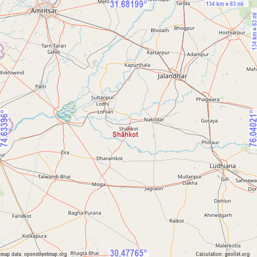
Shāhkot GPS coordinates[2]
31° 4' 54.228" North, 75° 20' 13.488" East
| Map corner | latitude | longitude |
|---|---|---|
| Upper-left | 31.68199°, | 74.63396° |
| Center: | 31.08173°, | 75.33708° |
| Lower-right: | 30.47765°, | 76.04021° |
| Map W x H: | 133.9×133.9 km | = 83.2×83.2mi |
| max Lat: | 34.9274° ⇑4.1% North |
| Shāhkot: | 31.08173° |
| min Lat: | ⇓95.9% South 8.09008° |
| min Long | Shāhkot | max Long |
| 68.82655° | 75.33708° | 96.81° |
| W 20.1%⇐ | ⇒79.9% E |
Elevation
Elevation of Shāhkot is 227 m = 745 ft, and this is 68.6 m = 225 ft below average elevation for this country.
| Max E: |
3681 m = 12077 ft | 44.9% |
| Avg. | 295.6 m = 970 ft | |
| Shāhkot | 227 m = 745 ft | |
Min E: |
1 m = 3 ft | 55.1% |
See also: India elevation on elevation.city.
Geographical zone
Shāhkot is located in North temperate zone (between Tropic of Cancer and the Arctic Circle). Distance of this Northern Tropic circle is 850 km =528.2 mi to South.| Distance of | km | miles | from Shāhkot |
|---|---|---|---|
| North Pole | 6551.1 | 4070.7 | to North |
| Arctic Circle | 3945.2 | 2451.4 | to North |
| Tropic Cancer | 850 | 528.2 | to South |
| Equator | 3456 | 2147.5 | to South |


Nearby cities:
15 places around Shāhkot: (largest is in red/bold)
• Badhni Kalān
44.7 km =27.8 mi,  185°
185°
• Jagraon
35.2 km =21.9 mi,  158°
158°
• Jalandhar
35.6 km =22.1 mi,  40°
40°
• Jandiāla
28.1 km =17.5 mi,  72°
72°
• Kapūrthala
33.4 km =20.8 mi,  7°
7°
• Kartārpur
43 km =26.7 mi,  20°
20°
• Kot Īsa Khān
24.2 km =15 mi,  231°
231°
• Makhu
32.5 km =20.2 mi,  274°
274°
• Moga
33.8 km =21 mi,  208°
208°
• Nakodar
14 km =8.7 mi, 69°
• Nūrmahal
24.5 km =15.2 mi,  86°
86°
• Phagwāra
44.5 km =27.7 mi, 69°
• Phillaur
43.8 km =27.2 mi,  99°
99°
• Sultanpur
20 km =12.4 mi,  317°
317°
• Zira
35.3 km =21.9 mi,  249°
249°
Sources, notices
• [Note1] Compared only with cities in India existing in our database
• [Src1] Map data: © OpenStreetMap contributors (CC-BY-SA)
• [Src2] Other city data from geonames.org with taken over terms of usage.
• [Src3] Geographical zone / Annual Mean Temperature by Robert A. Rohde @ Wikipedia
