Tarn Tāran geodata
Tarn Tāran (Punjab) is a populated place; located in India in Asia/Kolkata (GMT+5.5) time zone. With population of 58,585 people, there are 751 cities with bigger population in this country. Compared to other cities in India, 96.8% of cities are located further ↓South; 83.4% of cities are located further →East and 55.1% of cities have lower elevation than Tarn Tāran. Note1


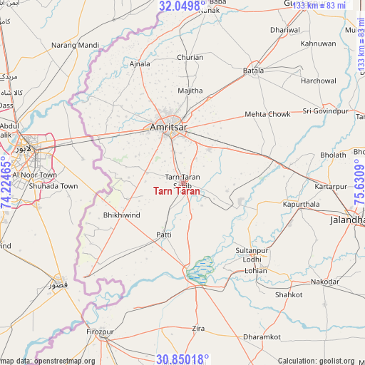
Tarn Tāran GPS coordinates[2]
31° 27' 6.876" North, 74° 55' 39.972" East
| Map corner | latitude | longitude |
|---|---|---|
| Upper-left | 32.0498°, | 74.22465° |
| Center: | 31.45191°, | 74.92777° |
| Lower-right: | 30.85018°, | 75.6309° |
| Map W x H: | 133.4×133.4 km | = 82.9×82.9mi |
| max Lat: | 34.9274° ⇑3.2% North |
| Tarn Tāran: | 31.45191° |
| min Lat: | ⇓96.8% South 8.09008° |
| min Long | Tarn Tāran | max Long |
| 68.82655° | 74.92777° | 96.81° |
| W 16.6%⇐ | ⇒83.4% E |
Elevation
Elevation of Tarn Tāran is 227 m = 745 ft, and this is 68.6 m = 225 ft below average elevation for this country.
| Max E: |
3681 m = 12077 ft | 44.9% |
| Avg. | 295.6 m = 970 ft | |
| Tarn Tāran | 227 m = 745 ft | |
Min E: |
1 m = 3 ft | 55.1% |
See also: Tarn Tāran elevation on elevation.city.
Geographical zone
Tarn Tāran is located in North temperate zone (between Tropic of Cancer and the Arctic Circle). Distance of this Northern Tropic circle is 891.2 km =553.8 mi to South.| Distance of | km | miles | from Tarn Tāran |
|---|---|---|---|
| North Pole | 6509.9 | 4045.1 | to North |
| Arctic Circle | 3904 | 2425.8 | to North |
| Tropic Cancer | 891.2 | 553.8 | to South |
| Equator | 3497.1 | 2173 | to South |


Nearby cities:
15 places around Tarn Tāran: (largest is in red/bold)
• Ajnāla
46.4 km =28.8 mi,  340°
340°
• Amritsar
19.6 km =12.2 mi,  345°
345°
• Batāla
47.5 km =29.5 mi,  33°
33°
• Dhilwan
40.2 km =25 mi,  80°
80°
• Fatehgarh Chūriān
45.9 km =28.5 mi,  3°
3°
• Jandiāla Gurū
15.5 km =9.6 mi,  37°
37°
• Kapūrthala
43.7 km =27.2 mi,  100°
100°
• Kartārpur
54.1 km =33.6 mi,  91°
91°
• Khem Karan
48.9 km =30.4 mi,  225°
225°
• Majītha
34.1 km =21.2 mi, 4°
• Makhu
39.3 km =24.4 mi,  170°
170°
• Patti
20.1 km =12.5 mi,  199°
199°
• Rāja Sānsi
32.2 km =20 mi, 338°
• Sultanpur
36.7 km =22.8 mi,  135°
135°
• Zira
54.1 km =33.6 mi, 173°
Sources, notices
• [Note1] Compared only with cities in India existing in our database
• [Src1] Map data: © OpenStreetMap contributors (CC-BY-SA)
• [Src2] Other city data from geonames.org with taken over terms of usage.
• [Src3] Geographical zone / Annual Mean Temperature by Robert A. Rohde @ Wikipedia
