Bandipura geodata
Bandipura (Jammu and Kashmir) is a populated place; located in India in Asia/Kolkata (GMT+5.5) time zone. With population of 31,978 people, there are 1358 cities with bigger population in this country. Compared to other cities in India, 99.9% of cities are located further ↓South; 85.7% of cities are located further →East and 98.4% of cities have lower elevation than Bandipura. Note1


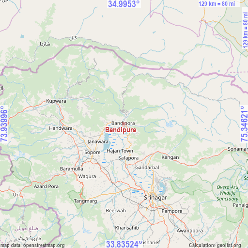
Bandipura GPS coordinates[2]
34° 25' 2.208" North, 74° 38' 35.088" East
| Map corner | latitude | longitude |
|---|---|---|
| Upper-left | 34.9953°, | 73.93996° |
| Center: | 34.41728°, | 74.64308° |
| Lower-right: | 33.83524°, | 75.34621° |
| Map W x H: | 129×129 km | = 80.2×80.2mi |
| max Lat: | 34.9274° ⇑0.1% North |
| Bandipura: | 34.41728° |
| min Lat: | ⇓99.9% South 8.09008° |
| min Long | Bandipura | max Long |
| 68.82655° | 74.64308° | 96.81° |
| W 14.3%⇐ | ⇒85.7% E |
Elevation
Elevation of Bandipura is 1607 m = 5272 ft, and this is 1311.4 m = 4302 ft above average elevation for this country.
| Max E: |
3681 m = 12077 ft | 1.6% |
| Bandipura | 1607 m 5272 ft | |
| Avg. | 295.6 m = 970 ft | |
Min E: |
1 m = 3 ft | 98.4% |
See also: India elevation on elevation.city.
Geographical zone
Bandipura is located in North temperate zone (between Tropic of Cancer and the Arctic Circle). Distance of this Northern Tropic circle is 1220.9 km =758.6 mi to South.| Distance of | km | miles | from Bandipura |
|---|---|---|---|
| North Pole | 6180.2 | 3840.2 | to North |
| Arctic Circle | 3574.3 | 2221 | to North |
| Tropic Cancer | 1220.9 | 758.6 | to South |
| Equator | 3826.8 | 2377.9 | to South |


Nearby cities:
15 places around Bandipura: (largest is in red/bold)
• Awantipur
65.1 km =40.5 mi,  148°
148°
• Bāramūla
36 km =22.4 mi,  229°
229°
• Gulmarg
47 km =29.2 mi,  210°
210°
• Gāndarbal
24.4 km =15.2 mi, 150°
• Hājan
13.4 km =8.3 mi,  190°
190°
• Kupwāra
55.3 km =34.4 mi,  219°
219°
• Māgām
36.4 km =22.6 mi, 187°
• Pattan
29.6 km =18.4 mi,  195°
195°
• Pulwama
64.8 km =40.3 mi,  158°
158°
• Sopur
21.4 km =13.3 mi, 227°
• Soyībug
38.3 km =23.8 mi,  171°
171°
• Srinagar
39.8 km =24.7 mi, 157°
• Sumbal
20.7 km =12.9 mi,  178°
178°
• Tsrār Sharīf
62.6 km =38.9 mi, 169°
• Uri
66.1 km =41.1 mi,  235°
235°
Sources, notices
• [Note1] Compared only with cities in India existing in our database
• [Src1] Map data: © OpenStreetMap contributors (CC-BY-SA)
• [Src2] Other city data from geonames.org with taken over terms of usage.
• [Src3] Geographical zone / Annual Mean Temperature by Robert A. Rohde @ Wikipedia
