Hājan geodata
Hājan (Jammu and Kashmir) is a populated place; located in India in Asia/Kolkata (GMT+5.5) time zone. With population of 10,800 people, there are 2855 cities with bigger population in this country. Compared to other cities in India, 99.9% of cities are located further ↓South; 85.8% of cities are located further →East and 98% of cities have lower elevation than Hājan. Note1


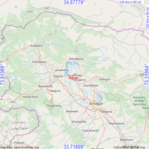
Hājan GPS coordinates[2]
34° 17' 56.22" North, 74° 37' 0.516" East
| Map corner | latitude | longitude |
|---|---|---|
| Upper-left | 34.87779°, | 73.91369° |
| Center: | 34.29895°, | 74.61681° |
| Lower-right: | 33.71609°, | 75.31994° |
| Map W x H: | 129.2×129.2 km | = 80.3×80.3mi |
| max Lat: | 34.9274° ⇑0.1% North |
| Hājan: | 34.29895° |
| min Lat: | ⇓99.9% South 8.09008° |
| min Long | Hājan | max Long |
| 68.82655° | 74.61681° | 96.81° |
| W 14.2%⇐ | ⇒85.8% E |
Elevation
Elevation of Hājan is 1582 m = 5190 ft, and this is 1286.4 m = 4220 ft above average elevation for this country.
| Max E: |
3681 m = 12077 ft | 2% |
| Hājan | 1582 m 5190 ft | |
| Avg. | 295.6 m = 970 ft | |
Min E: |
1 m = 3 ft | 98% |
See also: India elevation on elevation.city.
Geographical zone
Hājan is located in North temperate zone (between Tropic of Cancer and the Arctic Circle). Distance of this Northern Tropic circle is 1207.8 km =750.5 mi to South.| Distance of | km | miles | from Hājan |
|---|---|---|---|
| North Pole | 6193.4 | 3848.4 | to North |
| Arctic Circle | 3587.5 | 2229.2 | to North |
| Tropic Cancer | 1207.8 | 750.5 | to South |
| Equator | 3813.7 | 2369.7 | to South |


Nearby cities:
15 places around Hājan: (largest is in red/bold)
• Awantipur
55.9 km =34.7 mi,  138°
138°
• Bandipura
13.4 km =8.3 mi,  10°
10°
• Bāramūla
27.1 km =16.8 mi,  248°
248°
• Gulmarg
34.8 km =21.6 mi,  218°
218°
• Gāndarbal
16.6 km =10.3 mi,  119°
119°
• Kupwāra
44.1 km =27.4 mi,  227°
227°
• Māgām
23.1 km =14.4 mi,  186°
186°
• Pattan
16.3 km =10.1 mi,  199°
199°
• Pulwama
53.9 km =33.5 mi,  151°
151°
• Sopur
13.3 km =8.3 mi,  264°
264°
• Soyībug
26 km =16.2 mi,  161°
161°
• Srinagar
29.4 km =18.3 mi, 143°
• Sumbal
8.1 km =5 mi, 159°
• Tsrār Sharīf
50.3 km =31.3 mi, 164°
• Uri
57.4 km =35.7 mi,  244°
244°
Sources, notices
• [Note1] Compared only with cities in India existing in our database
• [Src1] Map data: © OpenStreetMap contributors (CC-BY-SA)
• [Src2] Other city data from geonames.org with taken over terms of usage.
• [Src3] Geographical zone / Annual Mean Temperature by Robert A. Rohde @ Wikipedia
