Sopur geodata
Sopur (Jammu and Kashmir) is a populated place; located in India in Asia/Kolkata (GMT+5.5) time zone. With population of 63,035 people, there are 700 cities with bigger population in this country. Compared to other cities in India, 99.9% of cities are located further ↓South; 87.1% of cities are located further →East and 98.1% of cities have lower elevation than Sopur. Note1


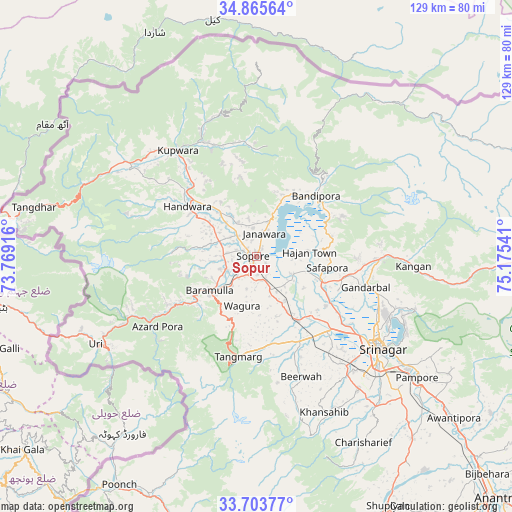
Sopur GPS coordinates[2]
34° 17' 12.156" North, 74° 28' 20.208" East
| Map corner | latitude | longitude |
|---|---|---|
| Upper-left | 34.86564°, | 73.76916° |
| Center: | 34.28671°, | 74.47228° |
| Lower-right: | 33.70377°, | 75.17541° |
| Map W x H: | 129.2×129.2 km | = 80.3×80.3mi |
| max Lat: | 34.9274° ⇑0.1% North |
| Sopur: | 34.28671° |
| min Lat: | ⇓99.9% South 8.09008° |
| min Long | Sopur | max Long |
| 68.82655° | 74.47228° | 96.81° |
| W 12.9%⇐ | ⇒87.1% E |
Elevation
Elevation of Sopur is 1583 m = 5194 ft, and this is 1287.4 m = 4224 ft above average elevation for this country.
| Max E: |
3681 m = 12077 ft | 1.9% |
| Sopur | 1583 m 5194 ft | |
| Avg. | 295.6 m = 970 ft | |
Min E: |
1 m = 3 ft | 98.1% |
See also: Sopur elevation on elevation.city.
Geographical zone
Sopur is located in North temperate zone (between Tropic of Cancer and the Arctic Circle). Distance of this Northern Tropic circle is 1206.4 km =749.6 mi to South.| Distance of | km | miles | from Sopur |
|---|---|---|---|
| North Pole | 6194.7 | 3849.2 | to North |
| Arctic Circle | 3588.8 | 2230 | to North |
| Tropic Cancer | 1206.4 | 749.6 | to South |
| Equator | 3812.3 | 2368.9 | to South |


Nearby cities:
15 places around Sopur: (largest is in red/bold)
• Awantipur
64.5 km =40.1 mi,  129°
129°
• Bandipura
21.4 km =13.3 mi,  47°
47°
• Bāramūla
14.7 km =9.1 mi,  234°
234°
• Gulmarg
27.2 km =16.9 mi,  197°
197°
• Gāndarbal
28.6 km =17.8 mi,  103°
103°
• Hājan
13.3 km =8.3 mi,  84°
84°
• Kupwāra
34.3 km =21.3 mi,  213°
213°
• Māgām
24.2 km =15 mi,  153°
153°
• Pattan
15.9 km =9.9 mi, 151°
• Pulwama
60.4 km =37.5 mi,  139°
139°
• Soyībug
31.7 km =19.7 mi, 137°
• Srinagar
37.9 km =23.5 mi, 126°
• Sumbal
17.2 km =10.7 mi,  111°
111°
• Tsrār Sharīf
54.3 km =33.7 mi, 150°
• Uri
45 km =28 mi,  239°
239°
Sources, notices
• [Note1] Compared only with cities in India existing in our database
• [Src1] Map data: © OpenStreetMap contributors (CC-BY-SA)
• [Src2] Other city data from geonames.org with taken over terms of usage.
• [Src3] Geographical zone / Annual Mean Temperature by Robert A. Rohde @ Wikipedia
