Uri geodata
Uri (Jammu and Kashmir) is a populated place; located in India in Asia/Kolkata (GMT+5.5) time zone. With population of 6,755 people, there are 3230 cities with bigger population in this country. Compared to other cities in India, 99.7% of cities are located further ↓South; 89% of cities are located further →East and 97.4% of cities have lower elevation than Uri. Note1


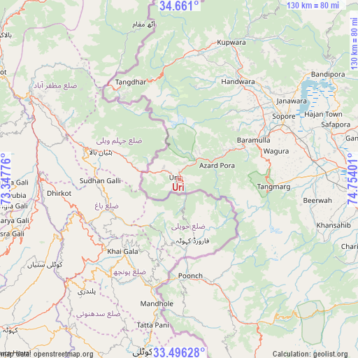
Uri GPS coordinates[2]
34° 4' 50.304" North, 74° 3' 3.168" East
| Map corner | latitude | longitude |
|---|---|---|
| Upper-left | 34.661°, | 73.34776° |
| Center: | 34.08064°, | 74.05088° |
| Lower-right: | 33.49628°, | 74.75401° |
| Map W x H: | 129.5×129.5 km | = 80.5×80.5mi |
| max Lat: | 34.9274° ⇑0.3% North |
| Uri: | 34.08064° |
| min Lat: | ⇓99.7% South 8.09008° |
| min Long | Uri | max Long |
| 68.82655° | 74.05088° | 96.81° |
| W 11%⇐ | ⇒89% E |
Elevation
Elevation of Uri is 1371 m = 4498 ft, and this is 1075.4 m = 3528 ft above average elevation for this country.
| Max E: |
3681 m = 12077 ft | 2.6% |
| Uri | 1371 m 4498 ft | |
| Avg. | 295.6 m = 970 ft | |
Min E: |
1 m = 3 ft | 97.4% |
See also: India elevation on elevation.city.
Geographical zone
Uri is located in North temperate zone (between Tropic of Cancer and the Arctic Circle). Distance of this Northern Tropic circle is 1183.5 km =735.4 mi to South.| Distance of | km | miles | from Uri |
|---|---|---|---|
| North Pole | 6217.6 | 3863.4 | to North |
| Arctic Circle | 3611.8 | 2244.3 | to North |
| Tropic Cancer | 1183.5 | 735.4 | to South |
| Equator | 3789.4 | 2354.6 | to South |


Nearby cities:
15 places around Uri: (largest is in red/bold)
• Bandipura
66.1 km =41.1 mi,  55°
55°
• Bāramūla
30.4 km =18.9 mi, 62°
• Gulmarg
30.6 km =19 mi,  95°
95°
• Gāndarbal
68.5 km =42.6 mi,  76°
76°
• Hājan
57.4 km =35.7 mi, 64°
• Kupwāra
20.4 km =12.7 mi,  105°
105°
• Māgām
49.7 km =30.9 mi,  88°
88°
• Pattan
47.4 km =29.5 mi, 79°
• Pūnch
34.7 km =21.6 mi,  173°
173°
• Sopur
45 km =28 mi, 59°
• Soyībug
60.3 km =37.5 mi, 90°
• Srinagar
69.5 km =43.2 mi, 89°
• Sumbal
57.3 km =35.6 mi,  73°
73°
• Thanna Mandi
67.2 km =41.8 mi,  153°
153°
• Tsrār Sharīf
70.2 km =43.6 mi, 110°
Sources, notices
• [Note1] Compared only with cities in India existing in our database
• [Src1] Map data: © OpenStreetMap contributors (CC-BY-SA)
• [Src2] Other city data from geonames.org with taken over terms of usage.
• [Src3] Geographical zone / Annual Mean Temperature by Robert A. Rohde @ Wikipedia
