Jagraon geodata
Jagraon (Punjab) is a populated place; located in India in Asia/Kolkata (GMT+5.5) time zone. With population of 65,305 people, there are 671 cities with bigger population in this country. Compared to other cities in India, 95.1% of cities are located further ↓South; 78.7% of cities are located further →East and 57.7% of cities have lower elevation than Jagraon. Note1


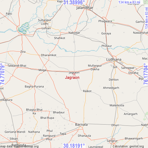
Jagraon GPS coordinates[2]
30° 47' 16.188" North, 75° 28' 26.076" East
| Map corner | latitude | longitude |
|---|---|---|
| Upper-left | 31.38996°, | 74.77079° |
| Center: | 30.78783°, | 75.47391° |
| Lower-right: | 30.18191°, | 76.17704° |
| Map W x H: | 134.3×134.3 km | = 83.5×83.5mi |
| max Lat: | 34.9274° ⇑4.9% North |
| Jagraon: | 30.78783° |
| min Lat: | ⇓95.1% South 8.09008° |
| min Long | Jagraon | max Long |
| 68.82655° | 75.47391° | 96.81° |
| W 21.3%⇐ | ⇒78.7% E |
Elevation
Elevation of Jagraon is 238 m = 781 ft, and this is 57.6 m = 189 ft below average elevation for this country.
| Max E: |
3681 m = 12077 ft | 42.3% |
| Avg. | 295.6 m = 970 ft | |
| Jagraon | 238 m = 781 ft | |
Min E: |
1 m = 3 ft | 57.7% |
See also: Jagraon elevation on elevation.city.
Geographical zone
Jagraon is located in North temperate zone (between Tropic of Cancer and the Arctic Circle). Distance of this Northern Tropic circle is 817.4 km =507.9 mi to South.| Distance of | km | miles | from Jagraon |
|---|---|---|---|
| North Pole | 6583.8 | 4091 | to North |
| Arctic Circle | 3977.9 | 2471.8 | to North |
| Tropic Cancer | 817.4 | 507.9 | to South |
| Equator | 3423.3 | 2127.1 | to South |


Nearby cities:
15 places around Jagraon: (largest is in red/bold)
• Badhni Kalān
21.1 km =13.1 mi,  235°
235°
• Barnāla
46.5 km =28.9 mi,  171°
171°
• Bhadaur
37.2 km =23.1 mi,  201°
201°
• Bāgha Purāna
37.6 km =23.4 mi,  252°
252°
• Jandiāla
43.5 km =27 mi,  18°
18°
• Kot Īsa Khān
36.6 km =22.7 mi,  298°
298°
• Ludhiāna
38.8 km =24.1 mi,  69°
69°
• Moga
29.3 km =18.2 mi,  275°
275°
• Māler Kotla
48.2 km =30 mi,  126°
126°
• Nakodar
37.6 km =23.4 mi,  0°
0°
• Nūrmahal
36.2 km =22.5 mi, 18°
• Phillaur
39.7 km =24.7 mi,  49°
49°
• Rāikot
19.5 km =12.1 mi,  141°
141°
• Shāhkot
35.2 km =21.9 mi,  338°
338°
• Zira
50.3 km =31.3 mi,  293°
293°
Sources, notices
• [Note1] Compared only with cities in India existing in our database
• [Src1] Map data: © OpenStreetMap contributors (CC-BY-SA)
• [Src2] Other city data from geonames.org with taken over terms of usage.
• [Src3] Geographical zone / Annual Mean Temperature by Robert A. Rohde @ Wikipedia
