Phillaur geodata
Phillaur (Punjab) is a populated place; located in India in Asia/Kolkata (GMT+5.5) time zone. With population of 22,588 people, there are 1869 cities with bigger population in this country. Compared to other cities in India, 95.8% of cities are located further ↓South; 75.7% of cities are located further →East and 59.3% of cities have lower elevation than Phillaur. Note1


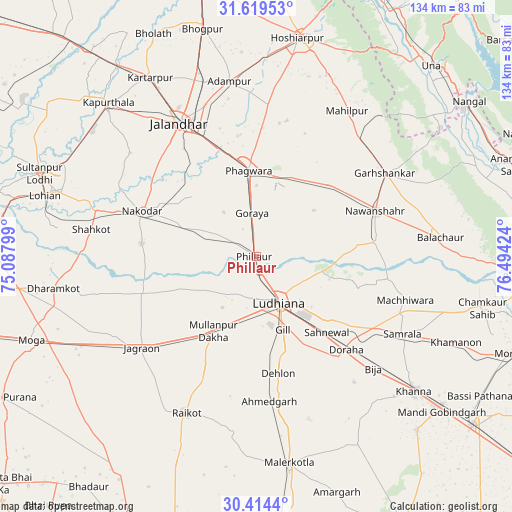
Phillaur GPS coordinates[2]
31° 1' 7.932" North, 75° 47' 27.996" East
| Map corner | latitude | longitude |
|---|---|---|
| Upper-left | 31.61953°, | 75.08799° |
| Center: | 31.01887°, | 75.79111° |
| Lower-right: | 30.4144°, | 76.49424° |
| Map W x H: | 134×134 km | = 83.3×83.3mi |
| max Lat: | 34.9274° ⇑4.2% North |
| Phillaur: | 31.01887° |
| min Lat: | ⇓95.8% South 8.09008° |
| min Long | Phillaur | max Long |
| 68.82655° | 75.79111° | 96.81° |
| W 24.3%⇐ | ⇒75.7% E |
Elevation
Elevation of Phillaur is 246 m = 807 ft, and this is 49.6 m = 163 ft below average elevation for this country.
| Max E: |
3681 m = 12077 ft | 40.7% |
| Avg. | 295.6 m = 970 ft | |
| Phillaur | 246 m = 807 ft | |
Min E: |
1 m = 3 ft | 59.3% |
See also: India elevation on elevation.city.
Geographical zone
Phillaur is located in North temperate zone (between Tropic of Cancer and the Arctic Circle). Distance of this Northern Tropic circle is 843.1 km =523.9 mi to South.| Distance of | km | miles | from Phillaur |
|---|---|---|---|
| North Pole | 6558.1 | 4075 | to North |
| Arctic Circle | 3952.2 | 2455.8 | to North |
| Tropic Cancer | 843.1 | 523.9 | to South |
| Equator | 3449 | 2143.1 | to South |


Nearby cities:
15 places around Phillaur: (largest is in red/bold)
• Banga
27.1 km =16.8 mi,  45°
45°
• Dorāha
33 km =20.5 mi,  137°
137°
• Garhshankar
39.9 km =24.8 mi,  56°
56°
• Jagraon
39.7 km =24.7 mi,  229°
229°
• Jalandhar
39.6 km =24.6 mi,  329°
329°
• Jandiāla
22.7 km =14.1 mi,  313°
313°
• Ludhiāna
13.3 km =8.3 mi,  153°
153°
• Māchhīwāra
40.7 km =25.3 mi,  106°
106°
• Nakodar
32.4 km =20.1 mi,  291°
291°
• Nawanshahr
33.1 km =20.6 mi,  69°
69°
• Nūrmahal
20.7 km =12.9 mi, 294°
• Phagwāra
22.9 km =14.2 mi,  355°
355°
• Rāhon
31.5 km =19.6 mi,  83°
83°
• Samrāla
43.4 km =27 mi,  117°
117°
• Shāhkot
43.8 km =27.2 mi,  279°
279°
Sources, notices
• [Note1] Compared only with cities in India existing in our database
• [Src1] Map data: © OpenStreetMap contributors (CC-BY-SA)
• [Src2] Other city data from geonames.org with taken over terms of usage.
• [Src3] Geographical zone / Annual Mean Temperature by Robert A. Rohde @ Wikipedia
