Sattenapalle geodata
Sattenapalle (Andhra Pradesh) is a populated place; located in India in Asia/Kolkata (GMT+5.5) time zone. With population of 53,603 people, there are 826 cities with bigger population in this country. Compared to other cities in India, 76.9% of cities are located further ↑North; 69.1% of cities are located further ←West and 73.3% of cities have higher elevation than Sattenapalle. Note1


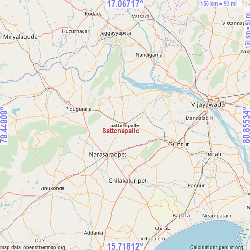
Sattenapalle GPS coordinates[2]
16° 23' 37.716" North, 80° 9' 7.956" East
| Map corner | latitude | longitude |
|---|---|---|
| Upper-left | 17.06717°, | 79.44909° |
| Center: | 16.39381°, | 80.15221° |
| Lower-right: | 15.71812°, | 80.85534° |
| Map W x H: | 150×150 km | = 93.2×93.2mi |
| max Lat: | 34.9274° ⇑76.9% North |
| Sattenapalle: | 16.39381° |
| min Lat: | ⇓23.1% South 8.09008° |
| min Long | Sattenapalle | max Long |
| 68.82655° | 80.15221° | 96.81° |
| W 69.1%⇐ | ⇒30.9% E |
Elevation
Elevation of Sattenapalle is 78 m = 256 ft, and this is 217.6 m = 714 ft below average elevation for this country.
| Max E: |
3681 m = 12077 ft | 73.3% |
| Avg. | 295.6 m = 970 ft | |
| Sattenapalle | 78 m = 256 ft | |
Min E: |
1 m = 3 ft | 26.7% |
See also: Sattenapalle elevation on elevation.city.
Geographical zone
Sattenapalle is located in North Torrid zone (between Equator and Tropic of Cancer). Distance of this Northern Tropic circle is 783.1 km =486.6 mi to North.| Distance of | km | miles | from Sattenapalle |
|---|---|---|---|
| North Pole | 8184.2 | 5085.4 | to North |
| Arctic Circle | 5578.4 | 3466.3 | to North |
| Tropic Cancer | 783.1 | 486.6 | to North |
| Equator | 1822.8 | 1132.6 | to South |


Nearby cities:
15 places around Sattenapalle: (largest is in red/bold)
• Chilakalūrupet
33.8 km =21 mi,  177°
177°
• Govindapuram,Chilakaluripet,Guntur
27.1 km =16.8 mi,  191°
191°
• Guntur
34.2 km =21.3 mi,  107°
107°
• Jaggayyapeta
55.9 km =34.7 mi,  354°
354°
• Kolanukonda
49.3 km =30.6 mi,  82°
82°
• Kondapalle
48.6 km =30.2 mi,  58°
58°
• Mangalagiri
44.6 km =27.7 mi, 84°
• Nandigāma
44.4 km =27.6 mi,  18°
18°
• Narasaraopet
20.8 km =12.9 mi,  211°
211°
• Phirangipuram
16.4 km =10.2 mi,  134°
134°
• Ponnur
55.5 km =34.5 mi, 130°
• Ponnūru
56.2 km =34.9 mi, 130°
• Tādepalle
48.8 km =30.3 mi, 78°
• Vijayawada
54.2 km =33.7 mi, 76°
• Yanamalakuduru
55.9 km =34.7 mi, 79°
Sources, notices
• [Note1] Compared only with cities in India existing in our database
• [Src1] Map data: © OpenStreetMap contributors (CC-BY-SA)
• [Src2] Other city data from geonames.org with taken over terms of usage.
• [Src3] Geographical zone / Annual Mean Temperature by Robert A. Rohde @ Wikipedia
