Ponnur geodata
Ponnur (Andhra Pradesh) is a populated place; located in India in Asia/Kolkata (GMT+5.5) time zone. With population of 56,504 people, there are 784 cities with bigger population in this country. Compared to other cities in India, 77.8% of cities are located further ↑North; 71.1% of cities are located further ←West and 95.4% of cities have higher elevation than Ponnur. Note1


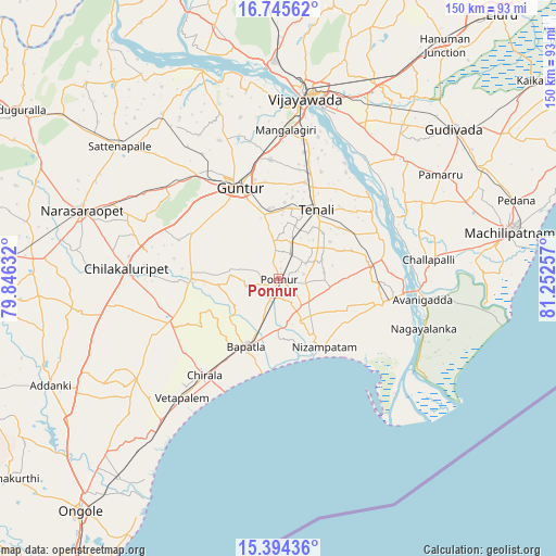
Ponnur GPS coordinates[2]
16° 4' 16.104" North, 80° 32' 57.984" East
| Map corner | latitude | longitude |
|---|---|---|
| Upper-left | 16.74562°, | 79.84632° |
| Center: | 16.07114°, | 80.54944° |
| Lower-right: | 15.39436°, | 81.25257° |
| Map W x H: | 150.2×150.2 km | = 93.3×93.3mi |
| max Lat: | 34.9274° ⇑77.8% North |
| Ponnur: | 16.07114° |
| min Lat: | ⇓22.2% South 8.09008° |
| min Long | Ponnur | max Long |
| 68.82655° | 80.54944° | 96.81° |
| W 71.1%⇐ | ⇒28.9% E |
Elevation
Elevation of Ponnur is 11 m = 36 ft, and this is 284.6 m = 934 ft below average elevation for this country.
| Max E: |
3681 m = 12077 ft | 95.4% |
| Avg. | 295.6 m = 970 ft | |
| Ponnur | 11 m = 36 ft | |
Min E: |
1 m = 3 ft | 4.6% |
See also: Ponnur elevation on elevation.city.
Geographical zone
Ponnur is located in North Torrid zone (between Equator and Tropic of Cancer). Distance of this Northern Tropic circle is 819 km =508.9 mi to North.| Distance of | km | miles | from Ponnur |
|---|---|---|---|
| North Pole | 8220.1 | 5107.7 | to North |
| Arctic Circle | 5614.2 | 3488.5 | to North |
| Tropic Cancer | 819 | 508.9 | to North |
| Equator | 1786.9 | 1110.3 | to South |


Nearby cities:
15 places around Ponnur: (largest is in red/bold)
• Avanigadda
39.8 km =24.7 mi,  97°
97°
• Bhattiprolu
25 km =15.5 mi,  81°
81°
• Bāpatla
20.5 km =12.7 mi,  205°
205°
• Challapalle
41.1 km =25.5 mi, 82°
• Chilakalūrupet
40.9 km =25.4 mi,  272°
272°
• Chīrāla
34.7 km =21.6 mi,  217°
217°
• Guntur
27.3 km =17 mi,  338°
338°
• Kolanukonda
43.1 km =26.8 mi,  8°
8°
• Mangalagiri
40 km =24.9 mi,  2°
2°
• Phirangipuram
39.2 km =24.4 mi,  308°
308°
• Ponnūru
0.7 km =0.4 mi,  156°
156°
• Repalle
30.5 km =19 mi, 101°
• Tādepalle
46.1 km =28.6 mi, 6°
• Vetapālem
41.1 km =25.5 mi, 219°
• Vuyyūru
45.2 km =28.1 mi,  44°
44°
Sources, notices
• [Note1] Compared only with cities in India existing in our database
• [Src1] Map data: © OpenStreetMap contributors (CC-BY-SA)
• [Src2] Other city data from geonames.org with taken over terms of usage.
• [Src3] Geographical zone / Annual Mean Temperature by Robert A. Rohde @ Wikipedia
