Chilakalūrupet geodata
Chilakalūrupet (Andhra Pradesh) is a populated place; located in India in Asia/Kolkata (GMT+5.5) time zone. With population of 94,011 people, there are 473 cities with bigger population in this country. Compared to other cities in India, 77.7% of cities are located further ↑North; 69.3% of cities are located further ←West and 84.4% of cities have higher elevation than Chilakalūrupet. Note1


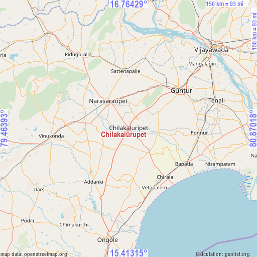
Chilakalūrupet GPS coordinates[2]
16° 5' 23.532" North, 80° 10' 1.38" East
| Map corner | latitude | longitude |
|---|---|---|
| Upper-left | 16.76429°, | 79.46393° |
| Center: | 16.08987°, | 80.16705° |
| Lower-right: | 15.41315°, | 80.87018° |
| Map W x H: | 150.2×150.2 km | = 93.3×93.3mi |
| max Lat: | 34.9274° ⇑77.7% North |
| Chilakalūrupet: | 16.08987° |
| min Lat: | ⇓22.3% South 8.09008° |
| min Long | Chilakalūrupet | max Long |
| 68.82655° | 80.16705° | 96.81° |
| W 69.3%⇐ | ⇒30.7% E |
Elevation
Elevation of Chilakalūrupet is 32 m = 105 ft, and this is 263.6 m = 865 ft below average elevation for this country.
| Max E: |
3681 m = 12077 ft | 84.4% |
| Avg. | 295.6 m = 970 ft | |
| Chilakalūrupet | 32 m = 105 ft | |
Min E: |
1 m = 3 ft | 15.6% |
See also: Chilakalūrupet elevation on elevation.city.
Geographical zone
Chilakalūrupet is located in North Torrid zone (between Equator and Tropic of Cancer). Distance of this Northern Tropic circle is 816.9 km =507.6 mi to North.| Distance of | km | miles | from Chilakalūrupet |
|---|---|---|---|
| North Pole | 8218 | 5106.4 | to North |
| Arctic Circle | 5612.1 | 3487.2 | to North |
| Tropic Cancer | 816.9 | 507.6 | to North |
| Equator | 1789 | 1111.6 | to South |


Nearby cities:
15 places around Chilakalūrupet: (largest is in red/bold)
• Addanki
37.3 km =23.2 mi,  213°
213°
• Bāpatla
38.2 km =23.7 mi,  122°
122°
• Chīrāla
35.6 km =22.1 mi,  146°
146°
• Govindapuram,Chilakaluripet,Guntur
10 km =6.2 mi,  316°
316°
• Guntur
38.8 km =24.1 mi,  53°
53°
• Mangalagiri
57.2 km =35.5 mi, 48°
• Narasaraopet
20.4 km =12.7 mi, 322°
• Pavuluru
26.3 km =16.3 mi,  180°
180°
• Phirangipuram
24.5 km =15.2 mi,  24°
24°
• Ponnur
40.9 km =25.4 mi,  92°
92°
• Ponnūru
41.2 km =25.6 mi, 93°
• Sattenapalle
33.8 km =21 mi,  357°
357°
• Vetapālem
37 km =23 mi,  156°
156°
• Vinukonda
45.8 km =28.5 mi,  264°
264°
• pedda nakkalapalem
24.8 km =15.4 mi, 181°
Sources, notices
• [Note1] Compared only with cities in India existing in our database
• [Src1] Map data: © OpenStreetMap contributors (CC-BY-SA)
• [Src2] Other city data from geonames.org with taken over terms of usage.
• [Src3] Geographical zone / Annual Mean Temperature by Robert A. Rohde @ Wikipedia
