Sangariā geodata
Sangariā (Rajasthan) is a populated place; located in India in Asia/Kolkata (GMT+5.5) time zone. With population of 38,638 people, there are 1137 cities with bigger population in this country. Compared to other cities in India, 92.2% of cities are located further ↓South; 87.1% of cities are located further →East and 51.7% of cities have higher elevation than Sangariā. Note1


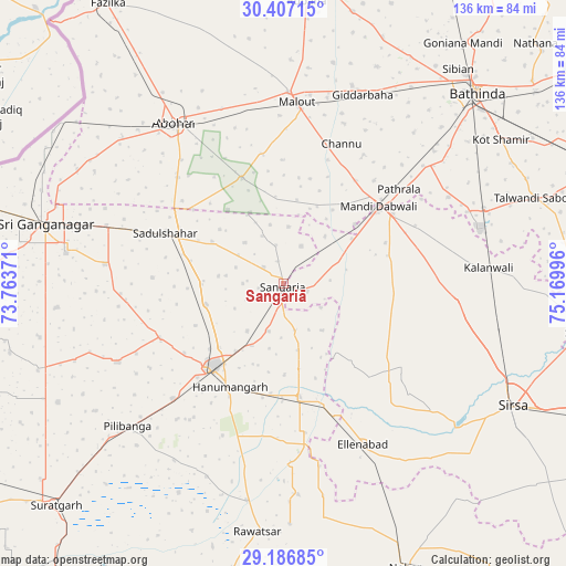
Sangariā GPS coordinates[2]
29° 47' 55.896" North, 74° 28' 0.588" East
| Map corner | latitude | longitude |
|---|---|---|
| Upper-left | 30.40715°, | 73.76371° |
| Center: | 29.79886°, | 74.46683° |
| Lower-right: | 29.18685°, | 75.16996° |
| Map W x H: | 135.7×135.7 km | = 84.3×84.3mi |
| max Lat: | 34.9274° ⇑7.8% North |
| Sangariā: | 29.79886° |
| min Lat: | ⇓92.2% South 8.09008° |
| min Long | Sangariā | max Long |
| 68.82655° | 74.46683° | 96.81° |
| W 12.9%⇐ | ⇒87.1% E |
Elevation
Elevation of Sangariā is 192 m = 630 ft, and this is 103.6 m = 340 ft below average elevation for this country.
| Max E: |
3681 m = 12077 ft | 51.7% |
| Avg. | 295.6 m = 970 ft | |
| Sangariā | 192 m = 630 ft | |
Min E: |
1 m = 3 ft | 48.3% |
See also: India elevation on elevation.city.
Geographical zone
Sangariā is located in North temperate zone (between Tropic of Cancer and the Arctic Circle). Distance of this Northern Tropic circle is 707.4 km =439.6 mi to South.| Distance of | km | miles | from Sangariā |
|---|---|---|---|
| North Pole | 6693.7 | 4159.3 | to North |
| Arctic Circle | 4087.9 | 2540.1 | to North |
| Tropic Cancer | 707.4 | 439.6 | to South |
| Equator | 3313.3 | 2058.8 | to South |


Nearby cities:
15 places around Sangariā: (largest is in red/bold)
• Abohar
46.5 km =28.9 mi,  325°
325°
• Bathinda
64.3 km =40 mi,  45°
45°
• Dabwāli
31 km =19.3 mi,  57°
57°
• Ellenabad
42.8 km =26.6 mi,  153°
153°
• Gangānagar
58.6 km =36.4 mi,  283°
283°
• Giddarbāha
48.5 km =30.1 mi,  23°
23°
• Hanumāngarh
27.5 km =17.1 mi,  208°
208°
• Kālānwāli
48.9 km =30.4 mi,  85°
85°
• Malaut
45.9 km =28.5 mi,  1°
1°
• Muktsar
75.2 km =46.7 mi, 3°
• Nohar
74.5 km =46.3 mi,  156°
156°
• Pilibangan
52.5 km =32.6 mi,  222°
222°
• Rānia
47 km =29.2 mi,  130°
130°
• Rāwatsār
59.4 km =36.9 mi,  185°
185°
• Sirsa
61.7 km =38.3 mi,  118°
118°
Sources, notices
• [Note1] Compared only with cities in India existing in our database
• [Src1] Map data: © OpenStreetMap contributors (CC-BY-SA)
• [Src2] Other city data from geonames.org with taken over terms of usage.
• [Src3] Geographical zone / Annual Mean Temperature by Robert A. Rohde @ Wikipedia
