Gangānagar geodata
Gangānagar (Rajasthan) is a populated place; located in India in Asia/Kolkata (GMT+5.5) time zone. With population of 231,838 people, there are 183 cities with bigger population in this country. Compared to other cities in India, 92.6% of cities are located further ↓South; 90.5% of cities are located further →East and 54.8% of cities have higher elevation than Gangānagar. Note1


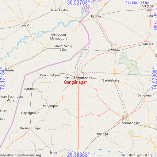
Gangānagar GPS coordinates[2]
29° 55' 12.324" North, 73° 52' 29.856" East
| Map corner | latitude | longitude |
|---|---|---|
| Upper-left | 30.52763°, | 73.17184° |
| Center: | 29.92009°, | 73.87496° |
| Lower-right: | 29.30882°, | 74.57809° |
| Map W x H: | 135.5×135.5 km | = 84.2×84.2mi |
| max Lat: | 34.9274° ⇑7.4% North |
| Gangānagar: | 29.92009° |
| min Lat: | ⇓92.6% South 8.09008° |
| min Long | Gangānagar | max Long |
| 68.82655° | 73.87496° | 96.81° |
| W 9.5%⇐ | ⇒90.5% E |
Elevation
Elevation of Gangānagar is 176 m = 577 ft, and this is 119.6 m = 392 ft below average elevation for this country.
| Max E: |
3681 m = 12077 ft | 54.8% |
| Avg. | 295.6 m = 970 ft | |
| Gangānagar | 176 m = 577 ft | |
Min E: |
1 m = 3 ft | 45.2% |
See also: Gangānagar elevation on elevation.city.
Geographical zone
Gangānagar is located in North temperate zone (between Tropic of Cancer and the Arctic Circle). Distance of this Northern Tropic circle is 720.9 km =447.9 mi to South.| Distance of | km | miles | from Gangānagar |
|---|---|---|---|
| North Pole | 6680.3 | 4150.9 | to North |
| Arctic Circle | 4074.4 | 2531.7 | to North |
| Tropic Cancer | 720.9 | 447.9 | to South |
| Equator | 3326.8 | 2067.2 | to South |


Nearby cities:
15 places around Gangānagar: (largest is in red/bold)
• Abohar
39.7 km =24.7 mi,  51°
51°
• Dabwāli
83.3 km =51.8 mi,  87°
87°
• Fāzilka
55.6 km =34.5 mi,  15°
15°
• Giddarbāha
82.2 km =51.1 mi,  67°
67°
• Hanumāngarh
57.8 km =35.9 mi,  130°
130°
• Jalālābād
84.7 km =52.6 mi,  25°
25°
• Karanpur
41.4 km =25.7 mi,  257°
257°
• Malaut
66.8 km =41.5 mi,  60°
60°
• Muktsar
87.2 km =54.2 mi, 45°
• Padampur
33.6 km =20.9 mi,  225°
225°
• Pilibangan
56.7 km =35.2 mi,  157°
157°
• Rāisinghnagar
59.3 km =36.8 mi,  223°
223°
• Rāwatsār
88.7 km =55.1 mi,  144°
144°
• Sangariā
58.6 km =36.4 mi,  103°
103°
• Sūratgarh
66.6 km =41.4 mi,  177°
177°
Sources, notices
• [Note1] Compared only with cities in India existing in our database
• [Src1] Map data: © OpenStreetMap contributors (CC-BY-SA)
• [Src2] Other city data from geonames.org with taken over terms of usage.
• [Src3] Geographical zone / Annual Mean Temperature by Robert A. Rohde @ Wikipedia
