Malaut geodata
Malaut (Punjab) is a populated place; located in India in Asia/Kolkata (GMT+5.5) time zone. With population of 76,616 people, there are 572 cities with bigger population in this country. Compared to other cities in India, 93.5% of cities are located further ↓South; 86.9% of cities are located further →East and 51.3% of cities have higher elevation than Malaut. Note1


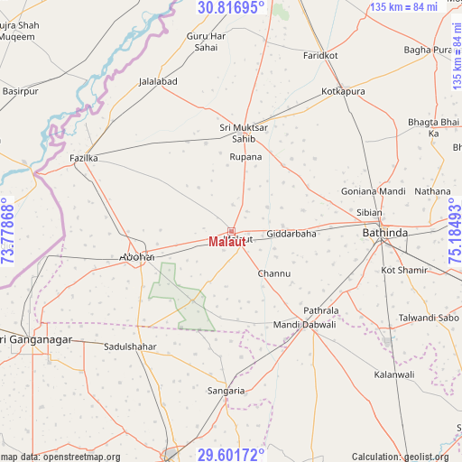
Malaut GPS coordinates[2]
30° 12' 40.356" North, 74° 28' 54.48" East
| Map corner | latitude | longitude |
|---|---|---|
| Upper-left | 30.81695°, | 73.77868° |
| Center: | 30.21121°, | 74.4818° |
| Lower-right: | 29.60172°, | 75.18493° |
| Map W x H: | 135.1×135.1 km | = 83.9×83.9mi |
| max Lat: | 34.9274° ⇑6.5% North |
| Malaut: | 30.21121° |
| min Lat: | ⇓93.5% South 8.09008° |
| min Long | Malaut | max Long |
| 68.82655° | 74.4818° | 96.81° |
| W 13.1%⇐ | ⇒86.9% E |
Elevation
Elevation of Malaut is 195 m = 640 ft, and this is 100.6 m = 330 ft below average elevation for this country.
| Max E: |
3681 m = 12077 ft | 51.3% |
| Avg. | 295.6 m = 970 ft | |
| Malaut | 195 m = 640 ft | |
Min E: |
1 m = 3 ft | 48.7% |
See also: Malaut elevation on elevation.city.
Geographical zone
Malaut is located in North temperate zone (between Tropic of Cancer and the Arctic Circle). Distance of this Northern Tropic circle is 753.3 km =468.1 mi to South.| Distance of | km | miles | from Malaut |
|---|---|---|---|
| North Pole | 6647.9 | 4130.8 | to North |
| Arctic Circle | 4042 | 2511.6 | to North |
| Tropic Cancer | 753.3 | 468.1 | to South |
| Equator | 3359.2 | 2087.3 | to South |


Nearby cities:
15 places around Malaut: (largest is in red/bold)
• Abohar
28.5 km =17.7 mi,  254°
254°
• Bathinda
43.9 km =27.3 mi,  90°
90°
• Dabwāli
38.2 km =23.7 mi,  139°
139°
• Farīdkot
57.8 km =35.9 mi,  27°
27°
• Fāzilka
48.4 km =30.1 mi,  295°
295°
• Gangānagar
66.8 km =41.5 mi,  240°
240°
• Giddarbāha
17.8 km =11.1 mi, 94°
• Guru Har Sahāi
55.8 km =34.7 mi,  352°
352°
• Hanumāngarh
71.5 km =44.4 mi,  191°
191°
• Jaito
47.6 km =29.6 mi,  55°
55°
• Jalālābād
48.9 km =30.4 mi,  333°
333°
• Kotkapura
53.2 km =33.1 mi,  39°
39°
• Kālānwāli
63 km =39.1 mi,  131°
131°
• Muktsar
29.4 km =18.3 mi,  6°
6°
• Sangariā
45.9 km =28.5 mi,  181°
181°
Sources, notices
• [Note1] Compared only with cities in India existing in our database
• [Src1] Map data: © OpenStreetMap contributors (CC-BY-SA)
• [Src2] Other city data from geonames.org with taken over terms of usage.
• [Src3] Geographical zone / Annual Mean Temperature by Robert A. Rohde @ Wikipedia
