Ellenabad geodata
Ellenabad (Haryana) is a populated place; located in India in Asia/Kolkata (GMT+5.5) time zone. With population of 37,680 people, there are 1171 cities with bigger population in this country. Compared to other cities in India, 90.9% of cities are located further ↓South; 85.5% of cities are located further →East and 51% of cities have higher elevation than Ellenabad. Note1


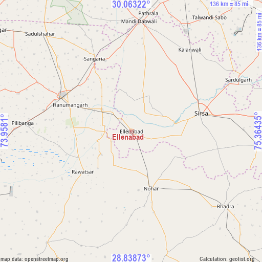
Ellenabad GPS coordinates[2]
29° 27' 10.152" North, 74° 39' 40.392" East
| Map corner | latitude | longitude |
|---|---|---|
| Upper-left | 30.06322°, | 73.9581° |
| Center: | 29.45282°, | 74.66122° |
| Lower-right: | 28.83873°, | 75.36435° |
| Map W x H: | 136.2×136.2 km | = 84.6×84.6mi |
| max Lat: | 34.9274° ⇑9.1% North |
| Ellenabad: | 29.45282° |
| min Lat: | ⇓90.9% South 8.09008° |
| min Long | Ellenabad | max Long |
| 68.82655° | 74.66122° | 96.81° |
| W 14.5%⇐ | ⇒85.5% E |
Elevation
Elevation of Ellenabad is 196 m = 643 ft, and this is 99.6 m = 327 ft below average elevation for this country.
| Max E: |
3681 m = 12077 ft | 51% |
| Avg. | 295.6 m = 970 ft | |
| Ellenabad | 196 m = 643 ft | |
Min E: |
1 m = 3 ft | 49% |
See also: India elevation on elevation.city.
Geographical zone
Ellenabad is located in North temperate zone (between Tropic of Cancer and the Arctic Circle). Distance of this Northern Tropic circle is 668.9 km =415.6 mi to South.| Distance of | km | miles | from Ellenabad |
|---|---|---|---|
| North Pole | 6732.2 | 4183.2 | to North |
| Arctic Circle | 4126.3 | 2564 | to North |
| Tropic Cancer | 668.9 | 415.6 | to South |
| Equator | 3274.8 | 2034.9 | to South |


Nearby cities:
15 places around Ellenabad: (largest is in red/bold)
• Bhādra
62.9 km =39.1 mi,  128°
128°
• Dabwāli
55.7 km =34.6 mi,  7°
7°
• Fatehābād
77.2 km =48 mi,  84°
84°
• Giddarbāha
83 km =51.6 mi,  0°
0°
• Hanumāngarh
35.2 km =21.9 mi,  294°
294°
• Kālānwāli
52.1 km =32.4 mi,  35°
35°
• Malaut
86.1 km =53.5 mi,  348°
348°
• Nohar
31.8 km =19.8 mi,  160°
160°
• Pilibangan
54.2 km =33.7 mi,  269°
269°
• Rānia
18.8 km =11.7 mi,  64°
64°
• Rāwatsār
32.4 km =20.1 mi,  230°
230°
• Sangariā
42.8 km =26.6 mi,  333°
333°
• Sardulgarh
61.6 km =38.3 mi, 64°
• Sirsa
36.7 km =22.8 mi, 75°
• Sūratgarh
75.2 km =46.7 mi,  258°
258°
Sources, notices
• [Note1] Compared only with cities in India existing in our database
• [Src1] Map data: © OpenStreetMap contributors (CC-BY-SA)
• [Src2] Other city data from geonames.org with taken over terms of usage.
• [Src3] Geographical zone / Annual Mean Temperature by Robert A. Rohde @ Wikipedia
