Rāwatsār geodata
Rāwatsār (Rajasthan) is a populated place; located in India in Asia/Kolkata (GMT+5.5) time zone. With population of 31,016 people, there are 1399 cities with bigger population in this country. Compared to other cities in India, 90% of cities are located further ↓South; 87.5% of cities are located further →East and 53.5% of cities have higher elevation than Rāwatsār. Note1


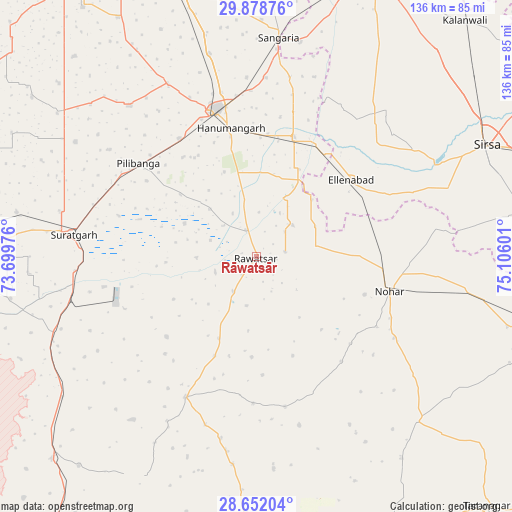
Rāwatsār GPS coordinates[2]
29° 16' 2.064" North, 74° 24' 10.368" East
| Map corner | latitude | longitude |
|---|---|---|
| Upper-left | 29.87876°, | 73.69976° |
| Center: | 29.26724°, | 74.40288° |
| Lower-right: | 28.65204°, | 75.10601° |
| Map W x H: | 136.4×136.4 km | = 84.8×84.8mi |
| max Lat: | 34.9274° ⇑10% North |
| Rāwatsār: | 29.26724° |
| min Lat: | ⇓90% South 8.09008° |
| min Long | Rāwatsār | max Long |
| 68.82655° | 74.40288° | 96.81° |
| W 12.5%⇐ | ⇒87.5% E |
Elevation
Elevation of Rāwatsār is 182 m = 597 ft, and this is 113.6 m = 373 ft below average elevation for this country.
| Max E: |
3681 m = 12077 ft | 53.5% |
| Avg. | 295.6 m = 970 ft | |
| Rāwatsār | 182 m = 597 ft | |
Min E: |
1 m = 3 ft | 46.5% |
See also: India elevation on elevation.city.
Geographical zone
Rāwatsār is located in North temperate zone (between Tropic of Cancer and the Arctic Circle). Distance of this Northern Tropic circle is 648.3 km =402.8 mi to South.| Distance of | km | miles | from Rāwatsār |
|---|---|---|---|
| North Pole | 6752.8 | 4196 | to North |
| Arctic Circle | 4147 | 2576.8 | to North |
| Tropic Cancer | 648.3 | 402.8 | to South |
| Equator | 3254.2 | 2022.1 | to South |


Nearby cities:
15 places around Rāwatsār: (largest is in red/bold)
• Bhādra
76.8 km =47.7 mi,  103°
103°
• Dabwāli
82.5 km =51.3 mi,  23°
23°
• Ellenabad
32.4 km =20.1 mi,  50°
50°
• Gangānagar
88.7 km =55.1 mi,  324°
324°
• Hanumāngarh
35.7 km =22.2 mi,  348°
348°
• Kālānwāli
83.8 km =52.1 mi,  41°
41°
• Nohar
36.9 km =22.9 mi, 104°
• Padampur
89.9 km =55.9 mi,  303°
303°
• Pilibangan
35.6 km =22.1 mi, 304°
• Rānia
50.9 km =31.6 mi,  55°
55°
• Sangariā
59.4 km =36.9 mi,  5°
5°
• Sardārshahr
92.3 km =57.4 mi,  174°
174°
• Sirsa
67.6 km =42 mi, 63°
• Sūratgarh
49.2 km =30.6 mi,  277°
277°
• Tārānagar
90.4 km =56.2 mi,  137°
137°
Sources, notices
• [Note1] Compared only with cities in India existing in our database
• [Src1] Map data: © OpenStreetMap contributors (CC-BY-SA)
• [Src2] Other city data from geonames.org with taken over terms of usage.
• [Src3] Geographical zone / Annual Mean Temperature by Robert A. Rohde @ Wikipedia
