Rānia geodata
Rānia (Haryana) is a populated place; located in India in Asia/Kolkata (GMT+5.5) time zone. With population of 22,741 people, there are 1855 cities with bigger population in this country. Compared to other cities in India, 91.3% of cities are located further ↓South; 84% of cities are located further →East and 50.3% of cities have lower elevation than Rānia. Note1


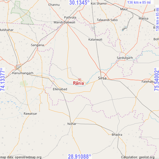
Rānia GPS coordinates[2]
29° 31' 28.344" North, 74° 50' 12.804" East
| Map corner | latitude | longitude |
|---|---|---|
| Upper-left | 30.1345°, | 74.13377° |
| Center: | 29.52454°, | 74.83689° |
| Lower-right: | 28.91088°, | 75.54002° |
| Map W x H: | 136.1×136.1 km | = 84.6×84.6mi |
| max Lat: | 34.9274° ⇑8.7% North |
| Rānia: | 29.52454° |
| min Lat: | ⇓91.3% South 8.09008° |
| min Long | Rānia | max Long |
| 68.82655° | 74.83689° | 96.81° |
| W 16%⇐ | ⇒84% E |
Elevation
Elevation of Rānia is 203 m = 666 ft, and this is 92.6 m = 304 ft below average elevation for this country.
| Max E: |
3681 m = 12077 ft | 49.7% |
| Avg. | 295.6 m = 970 ft | |
| Rānia | 203 m = 666 ft | |
Min E: |
1 m = 3 ft | 50.3% |
See also: India elevation on elevation.city.
Geographical zone
Rānia is located in North temperate zone (between Tropic of Cancer and the Arctic Circle). Distance of this Northern Tropic circle is 676.9 km =420.6 mi to South.| Distance of | km | miles | from Rānia |
|---|---|---|---|
| North Pole | 6724.2 | 4178.2 | to North |
| Arctic Circle | 4118.4 | 2559.1 | to North |
| Tropic Cancer | 676.9 | 420.6 | to South |
| Equator | 3282.8 | 2039.8 | to South |


Nearby cities:
15 places around Rānia: (largest is in red/bold)
• Bhādra
57 km =35.4 mi,  145°
145°
• Dabwāli
48.2 km =30 mi,  348°
348°
• Ellenabad
18.8 km =11.7 mi,  244°
244°
• Fatehābād
59.9 km =37.2 mi,  90°
90°
• Hanumāngarh
49.5 km =30.8 mi,  277°
277°
• Kālānwāli
37 km =23 mi,  20°
20°
• Maur
73.8 km =45.9 mi,  32°
32°
• Mānsa
75.1 km =46.7 mi,  46°
46°
• Nohar
38.5 km =23.9 mi,  189°
189°
• Pilibangan
71.7 km =44.6 mi,  263°
263°
• Ratia
73.9 km =45.9 mi,  75°
75°
• Rāwatsār
50.9 km =31.6 mi, 235°
• Sangariā
47 km =29.2 mi,  310°
310°
• Sardulgarh
42.9 km =26.7 mi,  64°
64°
• Sirsa
18.6 km =11.6 mi, 86°
Sources, notices
• [Note1] Compared only with cities in India existing in our database
• [Src1] Map data: © OpenStreetMap contributors (CC-BY-SA)
• [Src2] Other city data from geonames.org with taken over terms of usage.
• [Src3] Geographical zone / Annual Mean Temperature by Robert A. Rohde @ Wikipedia
