Māndvi geodata
Māndvi (Gujarat) is a populated place; located in India in Asia/Kolkata (GMT+5.5) time zone. With population of 47,853 people, there are 918 cities with bigger population in this country. Compared to other cities in India, 50.3% of cities are located further ↓South; 99.9% of cities are located further →East and 95.4% of cities have higher elevation than Māndvi. Note1


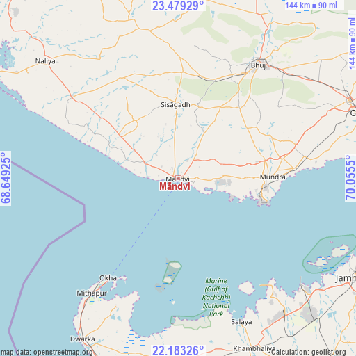
Māndvi GPS coordinates[2]
22° 49' 58.152" North, 69° 21' 8.532" East
| Map corner | latitude | longitude |
|---|---|---|
| Upper-left | 23.47929°, | 68.64925° |
| Center: | 22.83282°, | 69.35237° |
| Lower-right: | 22.18326°, | 70.0555° |
| Map W x H: | 144.1×144.1 km | = 89.5×89.5mi |
| max Lat: | 34.9274° ⇑49.7% North |
| Māndvi: | 22.83282° |
| min Lat: | ⇓50.3% South 8.09008° |
| min Long | Māndvi | max Long |
| 68.82655° | 69.35237° | 96.81° |
| W 0.1%⇐ | ⇒99.9% E |
Elevation
Elevation of Māndvi is 11 m = 36 ft, and this is 284.6 m = 934 ft below average elevation for this country.
| Max E: |
3681 m = 12077 ft | 95.4% |
| Avg. | 295.6 m = 970 ft | |
| Māndvi | 11 m = 36 ft | |
Min E: |
1 m = 3 ft | 4.6% |
See also: Māndvi elevation on elevation.city.
Geographical zone
Māndvi is located in North Torrid zone (between Equator and Tropic of Cancer). Distance of this Northern Tropic circle is 67.1 km =41.7 mi to North.| Distance of | km | miles | from Māndvi |
|---|---|---|---|
| North Pole | 7468.3 | 4640.6 | to North |
| Arctic Circle | 4862.4 | 3021.4 | to North |
| Tropic Cancer | 67.1 | 41.7 | to North |
| Equator | 2538.8 | 1577.5 | to South |


Nearby cities:
15 places around Māndvi: (largest is in red/bold)
• Anjār
75.7 km =47 mi,  65°
65°
• Bedi
79.9 km =49.6 mi,  117°
117°
• Bhuj
57 km =35.4 mi,  34°
34°
• Dwārka
76.9 km =47.8 mi,  210°
210°
• Gāndhīdhām
84.7 km =52.6 mi, 70°
• Jamnagar
83.5 km =51.9 mi, 118°
• Khambhāliya
76 km =47.2 mi,  156°
156°
• Kāndla
91.3 km =56.7 mi,  75°
75°
• Lālpur
95.1 km =59.1 mi,  138°
138°
• Mundra
37.9 km =23.5 mi,  88°
88°
• Naliya
71.8 km =44.6 mi,  311°
311°
• Okha
49.9 km =31 mi,  215°
215°
• Roha
41.3 km =25.7 mi,  348°
348°
• Salāya
63.6 km =39.5 mi, 156°
• Sikka
67.1 km =41.7 mi,  131°
131°
Sources, notices
• [Note1] Compared only with cities in India existing in our database
• [Src1] Map data: © OpenStreetMap contributors (CC-BY-SA)
• [Src2] Other city data from geonames.org with taken over terms of usage.
• [Src3] Geographical zone / Annual Mean Temperature by Robert A. Rohde @ Wikipedia
