Ratangarh geodata
Ratangarh (Rajasthan) is a populated place; located in India in Asia/Kolkata (GMT+5.5) time zone. With population of 66,625 people, there are 652 cities with bigger population in this country. Compared to other cities in India, 84.9% of cities are located further ↓South; 85.8% of cities are located further →East and 68.6% of cities have lower elevation than Ratangarh. Note1


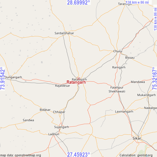
Ratangarh GPS coordinates[2]
28° 4' 52.932" North, 74° 37' 6.744" East
| Map corner | latitude | longitude |
|---|---|---|
| Upper-left | 28.69992°, | 73.91542° |
| Center: | 28.08137°, | 74.61854° |
| Lower-right: | 27.45923°, | 75.32167° |
| Map W x H: | 138×138 km | = 85.7×85.7mi |
| max Lat: | 34.9274° ⇑15.1% North |
| Ratangarh: | 28.08137° |
| min Lat: | ⇓84.9% South 8.09008° |
| min Long | Ratangarh | max Long |
| 68.82655° | 74.61854° | 96.81° |
| W 14.2%⇐ | ⇒85.8% E |
Elevation
Elevation of Ratangarh is 312 m = 1024 ft, and this is 16.4 m = 54 ft above average elevation for this country.
| Max E: |
3681 m = 12077 ft | 31.4% |
| Ratangarh | 312 m 1024 ft | |
| Avg. | 295.6 m = 970 ft | |
Min E: |
1 m = 3 ft | 68.6% |
See also: Ratangarh elevation on elevation.city.
Geographical zone
Ratangarh is located in North temperate zone (between Tropic of Cancer and the Arctic Circle). Distance of this Northern Tropic circle is 516.4 km =320.9 mi to South.| Distance of | km | miles | from Ratangarh |
|---|---|---|---|
| North Pole | 6884.7 | 4278 | to North |
| Arctic Circle | 4278.8 | 2658.7 | to North |
| Tropic Cancer | 516.4 | 320.9 | to South |
| Equator | 3122.4 | 1940.2 | to South |


Nearby cities:
15 places around Ratangarh: (largest is in red/bold)
• Bhuma
45.3 km =28.1 mi,  136°
136°
• Bhādāsar
41.4 km =25.7 mi,  308°
308°
• Bissāu
48.6 km =30.2 mi,  67°
67°
• Chhāpar
34.1 km =21.2 mi,  211°
211°
• Chūru
42.2 km =26.2 mi,  54°
54°
• Fatehpur
34.5 km =21.4 mi,  106°
106°
• Lachhmangarh Sīkar
49.4 km =30.7 mi,  125°
125°
• Lādnūn
52.2 km =32.4 mi,  204°
204°
• Meethari Marwar
56.6 km =35.2 mi,  173°
173°
• Nawalgarh
69.2 km =43 mi, 111°
• Rājaldesar
15.3 km =9.5 mi,  247°
247°
• Sardārshahr
41.9 km =26 mi,  342°
342°
• Sri Dūngargarh
59.8 km =37.2 mi,  271°
271°
• Sīkar
73.1 km =45.4 mi, 135°
• Sūjāngarh
45 km =28 mi, 199°
Sources, notices
• [Note1] Compared only with cities in India existing in our database
• [Src1] Map data: © OpenStreetMap contributors (CC-BY-SA)
• [Src2] Other city data from geonames.org with taken over terms of usage.
• [Src3] Geographical zone / Annual Mean Temperature by Robert A. Rohde @ Wikipedia
