Fatehpur geodata
Fatehpur (Rajasthan) is a populated place; located in India in Asia/Kolkata (GMT+5.5) time zone. With population of 83,170 people, there are 531 cities with bigger population in this country. Compared to other cities in India, 84.4% of cities are located further ↓South; 83.1% of cities are located further →East and 70.2% of cities have lower elevation than Fatehpur. Note1


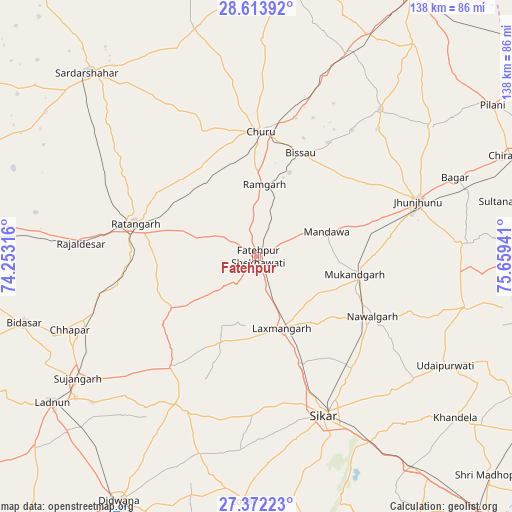
Fatehpur GPS coordinates[2]
27° 59' 41.496" North, 74° 57' 22.608" East
| Map corner | latitude | longitude |
|---|---|---|
| Upper-left | 28.61392°, | 74.25316° |
| Center: | 27.99486°, | 74.95628° |
| Lower-right: | 27.37223°, | 75.65941° |
| Map W x H: | 138.1×138.1 km | = 85.8×85.8mi |
| max Lat: | 34.9274° ⇑15.6% North |
| Fatehpur: | 27.99486° |
| min Lat: | ⇓84.4% South 8.09008° |
| min Long | Fatehpur | max Long |
| 68.82655° | 74.95628° | 96.81° |
| W 16.9%⇐ | ⇒83.1% E |
Elevation
Elevation of Fatehpur is 329 m = 1079 ft, and this is 33.4 m = 110 ft above average elevation for this country.
| Max E: |
3681 m = 12077 ft | 29.8% |
| Fatehpur | 329 m 1079 ft | |
| Avg. | 295.6 m = 970 ft | |
Min E: |
1 m = 3 ft | 70.2% |
See also: Fatehpur elevation on elevation.city.
Geographical zone
Fatehpur is located in North temperate zone (between Tropic of Cancer and the Arctic Circle). Distance of this Northern Tropic circle is 506.8 km =314.9 mi to South.| Distance of | km | miles | from Fatehpur |
|---|---|---|---|
| North Pole | 6894.3 | 4283.9 | to North |
| Arctic Circle | 4288.4 | 2664.7 | to North |
| Tropic Cancer | 506.8 | 314.9 | to South |
| Equator | 3112.7 | 1934.1 | to South |


Nearby cities:
15 places around Fatehpur: (largest is in red/bold)
• Bagar
57.5 km =35.7 mi,  68°
68°
• Bhuma
23.6 km =14.7 mi,  185°
185°
• Bissāu
30.5 km =19 mi,  22°
22°
• Chhāpar
54.4 km =33.8 mi,  248°
248°
• Chūru
34.4 km =21.4 mi,  1°
1°
• Jhunjhunūn
45.7 km =28.4 mi, 71°
• Lachhmangarh Sīkar
20.4 km =12.7 mi,  159°
159°
• Losal
66.3 km =41.2 mi,  183°
183°
• Meethari Marwar
53.6 km =33.3 mi,  209°
209°
• Nawalgarh
35 km =21.7 mi,  117°
117°
• Ratangarh
34.5 km =21.4 mi,  286°
286°
• Rājaldesar
47.4 km =29.5 mi,  274°
274°
• Sīkar
46.2 km =28.7 mi, 157°
• Sūjāngarh
58.2 km =36.2 mi,  235°
235°
• Udaipur
59 km =36.7 mi, 120°
Sources, notices
• [Note1] Compared only with cities in India existing in our database
• [Src1] Map data: © OpenStreetMap contributors (CC-BY-SA)
• [Src2] Other city data from geonames.org with taken over terms of usage.
• [Src3] Geographical zone / Annual Mean Temperature by Robert A. Rohde @ Wikipedia
