Bissāu geodata
Bissāu (Rajasthan) is a populated place; located in India in Asia/Kolkata (GMT+5.5) time zone. With population of 22,620 people, there are 1864 cities with bigger population in this country. Compared to other cities in India, 85.6% of cities are located further ↓South; 82.1% of cities are located further →East and 66.6% of cities have lower elevation than Bissāu. Note1


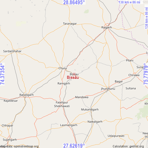
Bissāu GPS coordinates[2]
28° 14' 50.532" North, 75° 4' 35.976" East
| Map corner | latitude | longitude |
|---|---|---|
| Upper-left | 28.86495°, | 74.37354° |
| Center: | 28.24737°, | 75.07666° |
| Lower-right: | 27.62619°, | 75.77979° |
| Map W x H: | 137.7×137.7 km | = 85.6×85.6mi |
| max Lat: | 34.9274° ⇑14.4% North |
| Bissāu: | 28.24737° |
| min Lat: | ⇓85.6% South 8.09008° |
| min Long | Bissāu | max Long |
| 68.82655° | 75.07666° | 96.81° |
| W 17.9%⇐ | ⇒82.1% E |
Elevation
Elevation of Bissāu is 299 m = 981 ft, and this is 3.4 m = 11 ft above average elevation for this country.
| Max E: |
3681 m = 12077 ft | 33.4% |
| Bissāu | 299 m 981 ft | |
| Avg. | 295.6 m = 970 ft | |
Min E: |
1 m = 3 ft | 66.6% |
See also: India elevation on elevation.city.
Geographical zone
Bissāu is located in North temperate zone (between Tropic of Cancer and the Arctic Circle). Distance of this Northern Tropic circle is 534.9 km =332.4 mi to South.| Distance of | km | miles | from Bissāu |
|---|---|---|---|
| North Pole | 6866.2 | 4266.5 | to North |
| Arctic Circle | 4260.4 | 2647.3 | to North |
| Tropic Cancer | 534.9 | 332.4 | to South |
| Equator | 3140.8 | 1951.6 | to South |


Nearby cities:
15 places around Bissāu: (largest is in red/bold)
• Bagar
42 km =26.1 mi,  99°
99°
• Bhuma
53.5 km =33.2 mi,  195°
195°
• Chidawa
55.2 km =34.3 mi,  90°
90°
• Chūru
12.4 km =7.7 mi,  300°
300°
• Fatehpur
30.5 km =19 mi, 202°
• Jhunjhunūn
34.3 km =21.3 mi,  113°
113°
• Lachhmangarh Sīkar
47.4 km =29.5 mi,  185°
185°
• Nawalgarh
48.1 km =29.9 mi,  156°
156°
• Pilāni
53.3 km =33.1 mi,  75°
75°
• Ratangarh
48.6 km =30.2 mi,  247°
247°
• Rājaldesar
63.9 km =39.7 mi, 247°
• Rājgarh
53.3 km =33.1 mi,  34°
34°
• Sardārshahr
61.2 km =38 mi,  290°
290°
• Sūrajgarh
64.6 km =40.1 mi, 83°
• Tārānagar
47 km =29.2 mi,  354°
354°
Sources, notices
• [Note1] Compared only with cities in India existing in our database
• [Src1] Map data: © OpenStreetMap contributors (CC-BY-SA)
• [Src2] Other city data from geonames.org with taken over terms of usage.
• [Src3] Geographical zone / Annual Mean Temperature by Robert A. Rohde @ Wikipedia
