Lādnūn geodata
Lādnūn (Rajasthan) is a populated place; located in India in Asia/Kolkata (GMT+5.5) time zone. With population of 60,490 people, there are 724 cities with bigger population in this country. Compared to other cities in India, 82.8% of cities are located further ↓South; 87.5% of cities are located further →East and 69.5% of cities have lower elevation than Lādnūn. Note1


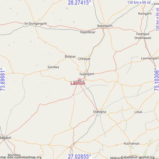
Lādnūn GPS coordinates[2]
27° 39' 11.232" North, 74° 23' 59.748" East
| Map corner | latitude | longitude |
|---|---|---|
| Upper-left | 28.27415°, | 73.69681° |
| Center: | 27.65312°, | 74.39993° |
| Lower-right: | 27.02855°, | 75.10306° |
| Map W x H: | 138.5×138.5 km | = 86.1×86.1mi |
| max Lat: | 34.9274° ⇑17.2% North |
| Lādnūn: | 27.65312° |
| min Lat: | ⇓82.8% South 8.09008° |
| min Long | Lādnūn | max Long |
| 68.82655° | 74.39993° | 96.81° |
| W 12.5%⇐ | ⇒87.5% E |
Elevation
Elevation of Lādnūn is 322 m = 1056 ft, and this is 26.4 m = 87 ft above average elevation for this country.
| Max E: |
3681 m = 12077 ft | 30.5% |
| Lādnūn | 322 m 1056 ft | |
| Avg. | 295.6 m = 970 ft | |
Min E: |
1 m = 3 ft | 69.5% |
See also: Lādnūn elevation on elevation.city.
Geographical zone
Lādnūn is located in North temperate zone (between Tropic of Cancer and the Arctic Circle). Distance of this Northern Tropic circle is 468.8 km =291.3 mi to South.| Distance of | km | miles | from Lādnūn |
|---|---|---|---|
| North Pole | 6932.3 | 4307.5 | to North |
| Arctic Circle | 4326.4 | 2688.3 | to North |
| Tropic Cancer | 468.8 | 291.3 | to South |
| Equator | 3074.7 | 1910.5 | to South |


Nearby cities:
15 places around Lādnūn: (largest is in red/bold)
• Bhuma
54.5 km =33.9 mi,  74°
74°
• Bhādāsar
74.3 km =46.2 mi,  351°
351°
• Chhāpar
18.8 km =11.7 mi,  11°
11°
• Dīdwāna
32.9 km =20.4 mi,  148°
148°
• Fatehpur
66.6 km =41.4 mi,  55°
55°
• Kuchāman
72.1 km =44.8 mi,  141°
141°
• Lachhmangarh Sīkar
64.6 km =40.1 mi, 73°
• Losal
58.2 km =36.2 mi,  118°
118°
• Makrāna
75 km =46.6 mi, 154°
• Meethari Marwar
29.5 km =18.3 mi,  106°
106°
• Ratangarh
52.2 km =32.4 mi,  24°
24°
• Rājaldesar
42.4 km =26.3 mi, 9°
• Sri Dūngargarh
62.5 km =38.8 mi,  322°
322°
• Sīkar
73 km =45.4 mi,  93°
93°
• Sūjāngarh
8.4 km =5.2 mi,  51°
51°
Sources, notices
• [Note1] Compared only with cities in India existing in our database
• [Src1] Map data: © OpenStreetMap contributors (CC-BY-SA)
• [Src2] Other city data from geonames.org with taken over terms of usage.
• [Src3] Geographical zone / Annual Mean Temperature by Robert A. Rohde @ Wikipedia
